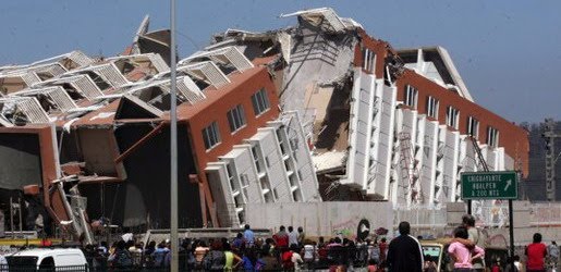
Earthquake
An earthquake (also known as a quake, tremor or temblor) is the result of a sudden release of energy in the Earth's crust that creates seismic waves.
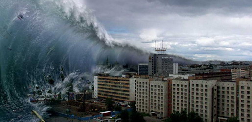
Tsunami
A tsunami also called a tsunami wave train, and at one time incorrectly referred to as a tidal wave, is a series of water waves caused by the displacement of a large volume of a body of water, usually an ocean, though it can occur in large lakes.
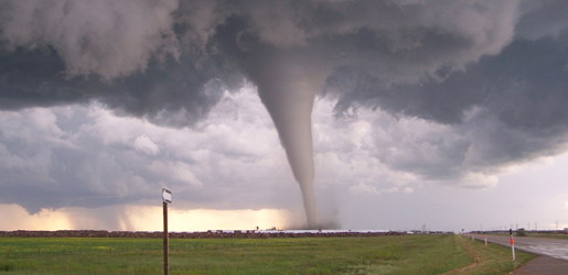
Tornado
A tornado (often referred to as a twister or, erroneously, a cyclone) is a violent, dangerous, rotating column of air that is in contact with both the surface of the earth and a cumulonimbus cloud or, in rare cases, the base of a cumulus cloud.
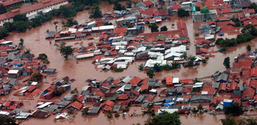
Floods
A flood is an overflow of an expanse of water that submerges land. The EU Floods directive defines a flood as a temporary covering by water of land not normally covered by water
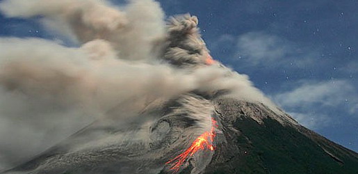
Volcanic Eruptions
Volcanoes can cause widespread destruction and consequent disaster through several ways. The effects include the volcanic eruption itself that may cause harm following the explosion of the volcano or the fall of rock.
7.4 Earthquake Struck Alaska
10:37 PM
The first quake occurred at a depth of about 40 km. Soon after the second earthquake measuring 7.2 magnitude occurred in the same area with the same depth. This was conveyed by the U.S. Geological Survey agency.
"Tsunami warning currently enforced and includes coastal areas of Alaska started to Unimak Pass, Alaska (80 miles northeast of Dutch Harbor) to the Amchitka Pass, Alaska (125 miles west adak)," the statement by Alaska Tsunami Warning Center and West Coast as reported by Reuters on Friday (24/06/2011).
Mentioned that an earthquake with the strength of this magnitude is known to cause a tsunami. If a tsunami occurs, the first tsunami wave will reach Adak, Alaska on Thursday, June 23 at 20:12 local time.
With this tsunami warning means all coastal residents who entered the territory of a tsunami warning, which is near the beach or lowland areas should go immediately to higher ground and away from the harbor and bay.
Notable Tropical Cyclone
1:00 AM

Tropical cyclones that cause extreme destruction are rare, although when they occur, they can cause great amounts of damage or thousands of fatalities. The 1970 Bhola cyclone is the deadliest tropical cyclone on record, killing more than 300,000 people and potentially as many as 1 million after striking the densely populated Ganges Delta region of Bangladesh on 13 November 1970. Its powerful storm surge was responsible for the high death toll. The North Indian cyclone basin has historically been the deadliest basin. Elsewhere, Typhoon Nina killed nearly 100,000 in China in 1975 due to a 100-year flood that caused 62 dams including the Banqiao Dam to fail. The Great Hurricane of 1780 is the deadliest Atlantic hurricane on record, killing about 22,000 people in the Lesser Antilles. A tropical cyclone does need not be particularly strong to cause memorable damage, primarily if the deaths are from rainfall or mudslides. Tropical Storm Thelma in November 1991 killed thousands in the Philippines, while in 1982, the unnamed tropical depression that eventually became Hurricane Paul killed around 1,000 people in Central America.
Hurricane Katrina is estimated as the costliest tropical cyclone worldwide, causing $81.2 billion in property damage (2008 USD) with overall damage estimates exceeding $100 billion (2005 USD). Katrina killed at least 1,836 people after striking Louisiana and Mississippi as a major hurricane in August 2005. Hurricane Andrew is the second most destructive tropical cyclone in U.S history, with damages totaling $40.7 billion (2008 USD), and with damage costs at $31.5 billion (2008 USD), Hurricane Ike is the third most destructive tropical cyclone in U.S history. The Galveston Hurricane of 1900 is the deadliest natural disaster in the United States, killing an estimated 6,000 to 12,000 people in Galveston, Texas. Hurricane Mitch caused more than 10,000 fatalities in Latin America. Hurricane Iniki in 1992 was the most powerful storm to strike Hawaii in recorded history, hitting Kauai as a Category 4 hurricane, killing six people, and causing U.S. $3 billion in damage. Other destructive Eastern Pacific hurricanes include Pauline and Kenna, both causing severe damage after striking Mexico as major hurricanes. In March 2004, Cyclone Gafilo struck northeastern Madagascar as a powerful cyclone, killing 74, affecting more than 200,000, and becoming the worst cyclone to affect the nation for more than 20 years.
The most intense storm on record was Typhoon Tip in the northwestern Pacific Ocean in 1979, which reached a minimum pressure of 870 mbar (25.69 inHg) and maximum sustained wind speeds of 165 knots (85 m/s) or 190 miles per hour (310 km/h). Tip, however, does not solely hold the record for fastest sustained winds in a cyclone. Typhoon Keith in the Pacific and Hurricanes Camille and Allen in the North Atlantic currently share this record with Tip.[119] Camille was the only storm to actually strike land while at that intensity, making it, with 165 knots (85 m/s) or 190 miles per hour (310 km/h) sustained winds and 183 knots (94 m/s) or 210 miles per hour (340 km/h) gusts, the strongest tropical cyclone on record at landfall.[120] Typhoon Nancy in 1961 had recorded wind speeds of 185 knots (95 m/s) or 215 miles per hour (346 km/h), but recent research indicates that wind speeds from the 1940s to the 1960s were gauged too high, and this is no longer considered the storm with the highest wind speeds on record. Similarly, a surface-level gust caused by Typhoon Paka on Guam was recorded at 205 knots (105 m/s) or 235 miles per hour (378 km/h). Had it been confirmed, it would be the strongest non-tornadic wind ever recorded on the Earth's surface, but the reading had to be discarded since the anemometer was damaged by the storm.
In addition to being the most intense tropical cyclone on record, Tip was the largest cyclone on record, with tropical storm-force winds 2,170 kilometres (1,350 mi) in diameter. The smallest storm on record, Tropical Storm Marco, formed during October 2008, and made landfall in Veracruz. Marco generated tropical storm-force winds only 37 kilometres (23 mi) in diameter.
Hurricane John is the longest-lasting tropical cyclone on record, lasting 31 days in 1994. Before the advent of satellite imagery in 1961, however, many tropical cyclones were underestimated in their durations. John is also the longest-tracked tropical cyclone in the Northern Hemisphere on record, which had a path of 7,165 miles (13,280 km). Reliable data for Southern Hemisphere cyclones is unavailable.Intensity Classifications of Tropical Cyclone
12:06 PM
Tropical cyclones are classified into three main groups, based on intensity: tropical depressions, tropical storms, and a third group of more intense storms, whose name depends on the region. For example, if a tropical storm in the Northwestern Pacific reaches hurricane-strength winds on the Beaufort scale, it is referred to as a typhoon; if a tropical storm passes the same benchmark in the Northeast Pacific Basin, or in the Atlantic, it is called a hurricane. Neither "hurricane" nor "typhoon" is used in either the Southern Hemisphere or the Indian Ocean. In these basins, storms of tropical nature are referred to simply as "cyclones".
Additionally, as indicated in the table below, each basin uses a separate system of terminology, making comparisons between different basins difficult. In the Pacific Ocean, hurricanes from the Central North Pacific sometimes cross the International Date Line into the Northwest Pacific, becoming typhoons (such as Hurricane/Typhoon Ioke in 2006); on rare occasions, the reverse will occur. It should also be noted that typhoons with sustained winds greater than 67 metres per second (130 kn) or 150 miles per hour (240 km/h) are called Super Typhoons by the Joint Typhoon Warning Center.
Tropical depression
A tropical depression is an organized system of clouds and thunderstorms with a defined, closed surface circulation and maximum sustained winds of less than 17 metres per second (33 kn) or 38 miles per hour (61 km/h). It has no eye and does not typically have the organization or the spiral shape of more powerful storms. However, it is already a low-pressure system, hence the name "depression". The practice of the Philippines is to name tropical depressions from their own naming convention when the depressions are within the Philippines' area of responsibility.
Tropical storm
A tropical storm is an organized system of strong thunderstorms with a defined surface circulation and maximum sustained winds between 17 metres per second (33 kn) (39 miles per hour (63 km/h)) and 32 metres per second (62 kn) (73 miles per hour (117 km/h)). At this point, the distinctive cyclonic shape starts to develop, although an eye is not usually present. Government weather services, other than the Philippines, first assign names to systems that reach this intensity (thus the term named storm).
Hurricane or typhoon
A hurricane or typhoon (sometimes simply referred to as a tropical cyclone, as opposed to a depression or storm) is a system with sustained winds of at least 33 metres per second (64 kn) or 74 miles per hour (119 km/h). A cyclone of this intensity tends to develop an eye, an area of relative calm (and lowest atmospheric pressure) at the center of circulation. The eye is often visible in satellite images as a small, circular, cloud-free spot. Surrounding the eye is the eyewall, an area about 16 kilometres (9.9 mi) to 80 kilometres (50 mi) wide in which the strongest thunderstorms and winds circulate around the storm's center. Maximum sustained winds in the strongest tropical cyclones have been estimated at about 85 metres per second (165 kn) or 195 miles per hour (314 km/h).
| Tropical Cyclone Classifications (all winds are 10-minute averages) | ||||||||
|---|---|---|---|---|---|---|---|---|
| Beaufort scale | 10-minute sustained winds (knots) | N Indian Ocean IMD | SW Indian Ocean MF | Australia BOM | SW Pacific FMS | NW Pacific JMA | NW Pacific JTWC | NE Pacific & N Atlantic NHC, CHC & CPHC |
| 0–6 | <28 knots (32 mph; 52 km/h) | Depression | Trop. Disturbance | Tropical Low | Tropical Depression | Tropical Depression | Tropical Depression | Tropical Depression |
| 7 | 28–29 knots (32–33 mph; 52–54 km/h) | Deep Depression | Depression | |||||
| 30–33 knots (35–38 mph; 56–61 km/h) | Tropical Storm | Tropical Storm | ||||||
| 8–9 | 34–47 knots (39–54 mph; 63–87 km/h) | Cyclonic Storm | Moderate Tropical Storm | Tropical Cyclone (1) | Tropical Cyclone (1) | Tropical Storm | ||
| 10 | 48–55 knots (55–63 mph; 89–102 km/h) | Severe Cyclonic Storm | Severe Tropical Storm | Tropical Cyclone (2) | Tropical Cyclone (2) | Severe Tropical Storm | ||
| 11 | 56–63 knots (64–72 mph; 104–117 km/h) | Typhoon | Hurricane (1) | |||||
| 12 | 64–72 knots (74–83 mph; 119–133 km/h) | Very Severe Cyclonic Storm | Tropical Cyclone | Severe Tropical Cyclone (3) | Severe Tropical Cyclone (3) | Typhoon | ||
| 73–85 knots (84–98 mph; 135–157 km/h) | Hurricane (2) | |||||||
| 86–89 knots (99–102 mph; 159–165 km/h) | Severe Tropical Cyclone (4) | Severe Tropical Cyclone (4) | Major Hurricane (3) | |||||
| 90–99 knots (100–114 mph; 170–183 km/h) | Intense Tropical Cyclone | |||||||
| 100–106 knots (120–122 mph; 190–196 km/h) | Major Hurricane (4) | |||||||
| 107–114 knots (123–131 mph; 198–211 km/h) | Severe Tropical Cyclone (5) | Severe Tropical Cyclone (5) | ||||||
| 115–119 knots (132–137 mph; 213–220 km/h) | Very Intense Tropical Cyclone | Super Typhoon | ||||||
| >120 knots (140 mph; 220 km/h) | Super Cyclonic Storm | Major Hurricane (5) | ||||||
Observation and Forecasting of Tropical Cyclone
11:57 AM
Tropical Cyclone Observation
 Intense tropical cyclones pose a particular observation challenge, as they are a dangerous oceanic phenomenon, and weather stations, being relatively sparse, are rarely available on the site of the storm itself. Surface observations are generally available only if the storm is passing over an island or a coastal area, or if there is a nearby ship. Usually, real-time measurements are taken in the periphery of the cyclone, where conditions are less catastrophic and its true strength cannot be evaluated. For this reason, there are teams of meteorologists that move into the path of tropical cyclones to help evaluate their strength at the point of landfall.
 Tropical cyclones far from land are tracked by weather satellites capturing visible and infrared images from space, usually at half-hour to quarter-hour intervals. As a storm approaches land, it can be observed by land-based Doppler radar. Radar plays a crucial role around landfall by showing a storm's location and intensity every several minutes.
In-situ measurements, in real-time, can be taken by sending specially equipped reconnaissance flights into the cyclone. In the Atlantic basin, these flights are regularly flown by United States government hurricane hunters. The aircraft used are WC-130 Hercules and WP-3D Orions, both four-engine turboprop cargo aircraft. These aircraft fly directly into the cyclone and take direct and remote-sensing measurements. The aircraft also launch GPS dropsondes inside the cyclone. These sondes measure temperature, humidity, pressure, and especially winds between flight level and the ocean's surface. A new era in hurricane observation began when a remotely piloted Aerosonde, a small drone aircraft, was flown through Tropical Storm Ophelia as it passed Virginia's Eastern Shore during the 2005 hurricane season. A similar mission was also completed successfully in the western Pacific ocean. This demonstrated a new way to probe the storms at low altitudes that human pilots seldom dare.
Tropical Cyclone Forecasting
 Because of the forces that affect tropical cyclone tracks, accurate track predictions depend on determining the position and strength of high- and low-pressure areas, and predicting how those areas will change during the life of a tropical system. The deep layer mean flow, or average wind through the depth of the troposphere, is considered the best tool in determining track direction and speed. If storms are significantly sheared, use of wind speed measurements at a lower altitude, such as at the 700 hPa pressure surface (3,000 metres / 9,800 feet above sea level) will produce better predictions. Tropical forecasters also consider smoothing out short-term wobbles of the storm as it allows them to determine a more accurate long-term trajectory. High-speed computers and sophisticated simulation software allow forecasters to produce computer models that predict tropical cyclone tracks based on the future position and strength of high- and low-pressure systems. Combining forecast models with increased understanding of the forces that act on tropical cyclones, as well as with a wealth of data from Earth-orbiting satellites and other sensors, scientists have increased the accuracy of track forecasts over recent decades. However, scientists are not as skillful at predicting the intensity of tropical cyclones. The lack of improvement in intensity forecasting is attributed to the complexity of tropical systems and an incomplete understanding of factors that affect their development.