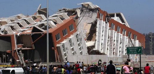
Earthquake
An earthquake (also known as a quake, tremor or temblor) is the result of a sudden release of energy in the Earth's crust that creates seismic waves.
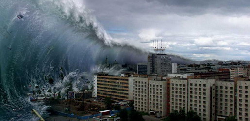
Tsunami
A tsunami also called a tsunami wave train, and at one time incorrectly referred to as a tidal wave, is a series of water waves caused by the displacement of a large volume of a body of water, usually an ocean, though it can occur in large lakes.
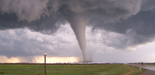
Tornado
A tornado (often referred to as a twister or, erroneously, a cyclone) is a violent, dangerous, rotating column of air that is in contact with both the surface of the earth and a cumulonimbus cloud or, in rare cases, the base of a cumulus cloud.
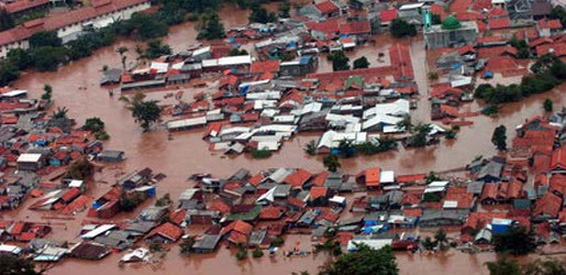
Floods
A flood is an overflow of an expanse of water that submerges land. The EU Floods directive defines a flood as a temporary covering by water of land not normally covered by water
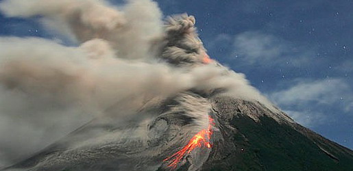
Volcanic Eruptions
Volcanoes can cause widespread destruction and consequent disaster through several ways. The effects include the volcanic eruption itself that may cause harm following the explosion of the volcano or the fall of rock.
Natural Disaster Picture
7:46 AM

Earthquake Picture

Tornado Picture

Flood Picture

Volcanic Eruption Picture

Highest and Tallest Tsunami
6:22 AM
The only other recent megatsunamis are the 1980 Spirit Lake megatsunami, which measured 260 m (780 ft) tall and the 1963 Vajont Dam megatsunami which had an initial height of 250 m (750 ft).
Prehistoric
- The asteroid which created the Chicxulub crater in Yucatan approximately 65 million years BP would have generated some of the largest megatsunami in Earth's history.
- A series of megatsunami were generated by the bolide impact that created the Chesapeake Bay impact crater, about 35.5 million years BP.
- At Seton Portage, British Columbia, Canada, a freshwater megatsunami may have occurred approximately 10,000 BP. A huge block of the Cayoosh Range suddenly slid northwards into what had been a large lake spanning the area from Lillooet, British Columbia to near Birken, in the Gates Valley or Pemberton Pass to the southwest. The event has not been studied in detail, but the proto-lake (freshwater fjord) may have been at least as deep as the two present-day halves, Seton and Anderson Lakes, on either side of the Portage, suggesting that the surge generated by the giant landslide in the narrow mountain confines of the fjord valley may have been comparable in scale to Lituya Bay. Another more recent landslide on the south shore of Anderson Lake dropped a large portion of high mountainside down a debris chute, creating a rockwall "fan" which must have made a megatsunami-type wave, though not as large as the main one at the Portage.
- Approximately 8,000 BP, a massive volcanic landslide off of Mt. Etna, Sicily caused a megatsunami which devastated the eastern Mediterranean coastline on three continents.
- In the Norwegian Sea, the Storegga Slide caused a megatsunami approximately 7,000 years BP.
- Approximately 4,000 BC, a landslide on Réunion island, to the east of Madagascar, may have caused a megatsunami.
- The recently discovered undersea Burckle Crater located at the bottom of the Indian Ocean would have caused a megatsunami at the time of impact estimated to be c. 3000–2800 BC. It is unknown whether the Burckle Crater is connected to the Fenambosy Chevron which provides evidence of another megatsunami.
- Evidence for large landslides has been found in the form of extensive underwater debris aprons around many volcanic ocean islands which are composed of the material which has slid into the ocean. The island of Molokai had a catastrophic collapse over a million years ago; this underwater landslide likely caused large tsunamis. In recent years, five such debris aprons have been located around the Hawaiian Islands. The Canary Islands have at least 14 such debris aprons associated with the archipelago.
Highest and Tallest Tsunami in Modern Era
1792: Mount Unzen, Japan
In 1792, Mount Unzen in Japan erupted, causing part of the volcano to collapse into the sea. The landslide caused a megatsunami that reached 100 meters (328 ft) high and killed 15,000 people in the local fishing villages.
1958: Lituya Bay, Alaska, USA
On 9 July 1958, a giant landslide at the head of Lituya Bay in Alaska, caused by an earthquake, generated a wave with an initial amplitude of 524 meters (1,719 ft). This is the highest wave ever recorded, and surged over the headland opposite, stripping trees and soil down to bedrock, and surged along the fjord which forms Lituya Bay, destroying a fishing boat anchored there and killing two people. Howard Ulrich and his son managed to ride the wave in their boat, and both survived.1963: Vajont Dam, Italy
On 9 October 1963, a landslide above Vajont Dam in Italy produced a 250 m (820 ft) surge that overtopped the dam and destroyed the villages of Longarone, Pirago, Rivalta, Villanova and Faè, killing nearly 2,000 people.
1980: Spirit Lake, Washington, USA
On May 18, 1980, the upper 460 meters of Mount St. Helens failed and detached in a massive landslide. This released the pressure on the magma trapped beneath the summit bulge which exploded as a lateral blast, which then released the over-pressure on the magma chamber and resulted in a plinian eruption.
One lobe of the avalanche surged onto Spirit Lake, causing a megatsunami which pushed the lake waters in a series of surges, which reached a maximum height of 260 metres above the pre-eruption water level (~975 m asl). Above the upper limit of the tsunami, trees lie where they were knocked down by the pyroclastic surge; below the limit, the fallen trees and the surge deposits were removed by the megatsunami and deposited in Spirit Lake.
Tsunami 2000s
6:19 AM
2004: Indian Ocean
The 2004 Indian Ocean earthquake, which had a moment magnitude of 9.1–9.3, triggered a series of lethal tsunamis on December 26, 2004, that killed approximately 230,210 people (including 168,000 in Indonesia alone), making it the deadliest tsunami as well as one of the deadliest natural disasters in recorded history. It was also caused by the third largest earthquake in recorded history. The initial surge was measured at a height of approximately 33 meters (108 ft), making it the largest earthquake-generated tsunami in recorded history. The tsunami killed people over an area ranging from the immediate vicinity of the quake in Indonesia, Thailand, and the north-western coast of Malaysia, to thousands of kilometres away in Bangladesh, India, Sri Lanka, the Maldives, and even as far away as Somalia, Kenya, and Tanzania in eastern Africa. This trans-Indian Ocean tsunami is an example of a teletsunami, which can travel vast distances across the open ocean. In this case, it is an ocean-wide tsunami.Unlike in the Pacific Ocean, there was no organized alert service covering the Indian Ocean. This was in part due to the absence of major tsunami events since 1883 (the Krakatoa eruption, which killed 36,000 people). In light of the 2004 Indian Ocean tsunami, UNESCO and other world bodies have called for an international tsunami monitoring system.
2006: South of Java Island
A 7.7 magnitude earthquake rocked the Indian Ocean seabed on July 17, 2006, 200 km south of Pangandaran, a beautiful beach famous to surfers for its perfect waves. This earthquake triggered tsunamis which height varied from 2 meters at Cilacap to 6 meters at Cimerak beach, where it swept away and flattened buildings as far as 400 meters away from the coastline. More than 800 people were reported missing or dead.
2006: Kuril Islands
On 15 November 2006, a magnitude 8.3 earthquake occurred off the coast near the Kuril Islands. In spite of the quake's large 8.3 magnitude, a relatively small tsunami was generated. The small tsunami was recorded or observed in Japan and at distant locations throughout the Pacific.
2007: Solomon Islands
On April 24, 2007, a powerful magnitude 8.1 (initially 7.6) earthquake hit the East Pacific region about 40 km (25 miles) northwest of the Solomon Islands at 7:39 a.m., resulting in a tsunami that was up to 5 m (17 feet) tall. The wave, which struck the coast of Solomon Islands (mainly Gizo), triggered region-wide tsunami warnings and watches extending from Japan to New Zealand to Hawaii and the eastern seaboard of Australia. The tsunami that followed the earthquake killed 52 people. Dozens more have been injured with entire towns inundated by the sweeping water which travelled 300 meters inland in some places. Simbo, Choiseul and Ranunga islands were also affected. A state of national emergency was declared for the Solomon Islands. On the island of Choiseul, a wall of water reported to be 9.1 m (30 feet) high swept almost 400 meters inland destroying everything in its path. Officials estimate that the tsunami displaced more than 5000 residents all over the archipelago.
2007: Niigata, Japan
On 16 July 2007, a strong earthquake struck northwestern Japan, causing a fire and minor radioactive water leak at one of the world's most powerful nuclear power plants. At least seven people were killed and hundreds injured. Japan's Meteorological Agency measured the quake at 6.8 on the richter scale and sending aftershocks of 6.6. The U.S. Geological Survey, which monitors quakes around the world, said the initial quake registered 6.7. A tsunami watch was issued along the Sea of Japan. The predicted height of the tsunami was estimated to be 50 cm (20 inches). That earthquake sparked only a few small tsunamis, growing to be no more than about 20 cm (8 inches) tall. However, the 1964 quake and tsunami north of the current one destroyed the port of the city of Niigata.
2010: Chile
The seismic event in the southern Pacific produced waves measuring 1.8–9 meters along the Sanriku Coastline of northeastern Honshu in Japan.2011: New Zealand
On February 22, 2011, a 6.3 magnitude earthquake hit the Canterbury Region of the South Island, New Zealand. Some 200 kilometres (120 mi) away from the earthquake's epicenter, around 30 million tonnes of ice tumbled off the Tasman Glacier into Tasman Lake, producing a series of 3.5 m (11 ft) high tsunami waves, which hit tourist boats in the lake.
2011: Pacific coast of Japan
On March 11, 2011, off the Pacific coast of Japan, a 9.0 magnitude earthquake produced a tsunami 33 feet (10 m) high along Japan's northeastern coast. The wave caused widespread devastation, with an official count of more than 25,000 people confirmed to be killed/missing. The highest tsunami which was recorded at Ryōri Bay, Ōfunato, reached a total height of 97 feet (30 m). In addition the tsunami precipitated a hydrogen explosion and a suspected partial nuclear meltdown at the Fukushima I Nuclear Power Plant. Tsunami warnings were issued to the entire Pacific Rim.
Tsunami 1950–2000
6:16 AM
1952: Severo-Kurilsk, Kuril Islands, USSR
The November 5, 1952 tsunami killed 2,336 on the Kuril Islands, USSR.
1958: Lituya Bay, Alaska, USA
On July 9, 1958, an earthquake caused a megatsunami to reach a height taller than the Empire State Building, measuring over 520 metres (1,706 ft), killing two.
1960: Valdivia, Chile
The magnitude-9.5 Great Chilean Earthquake of May 22, 1960 is the strongest earthquake ever recorded. Its epicenter, off the coast of South Central Chile, generated one of the most destructive tsunami of the 20th Century. It also caused a volcanic eruption.
It spread across the entire Pacific Ocean, with waves measuring up to 25 meters high. The first tsunami arrived at Hilo approximately 14.8 hrs after it originated off the coast of South Central Chile. The highest wave at Hilo Bay was measured at around 10.7 m (35 ft). 61 lives were lost allegedly due to people's failure to heed warning sirens.
Almost 22 hours after the quake, the waves hit the ill-fated Sanriku coast of Japan, reaching up to 3 m above high tide, and killed 142 people. Up to 6,000 people died in total worldwide due to the earthquake and tsunami.
1963: Vajont Dam, Monte Toc, Italy
The Vajont Dam was completed in 1961 under Monte Toc, 100 km north of Venice, Italy. At 262 metres, it was one of the highest dams in the world. On October 9, 1963 an enormous landslide of about 260 million cubic metres of forest, earth, and rock, fell into the reservoir at up to 110 km per hour (68 mph). The resulting displacement of water caused 50 million cubic metres of water to overtop the dam in a 250-metre high megatsunami wave. The flooding destroyed the villages of Longarone, Pirago, Rivalta, Villanova and Faè, killing 1,450 people. Almost 2,000 people (some sources report 1,909) perished in total.1964: Niigata, Japan
The 1964 Niigata earthquake in Japan killed 28 people, and liquefacted whole apartment buildings. A subsequent tsunami destroyed the port of Niigata city.
1964: Alaska, USA
After the magnitude 9.2 Good Friday Earthquake, tsunamis struck Alaska, British Columbia, California, and coastal Pacific Northwest towns, killing 121 people. The waves were up to 100 feet tall, and killed 11 people as far away as Crescent City, California. This happened on March 27, 1964. The incident was covered in Dennis Powers' The Raging Sea: The Powerful Account of the Worst Tsunami in U.S. History (ISBN 0806526823).
1976: Moro Gulf, Mindanao, Philippines
On August 16, 1976 at 12:11 A.M., a devastating earthquake of 7.9 hit the island of Mindanao, Philippines. It created a tsunami that devastated more than 700 km of coastline bordering Moro Gulf in the North Celebes Sea. An estimated number of victims for this tragedy left 5,000 dead, 2,200 missing or presumed dead, more than 9,500 injured and a total of 93,500 people were left homeless. It devastated the cities of Cotabato, Pagadian, and Zamboanga, and the and provinces of Basilan, Lanao del Norte, Lanao del Sur, Maguindanao, Sultan Kudarat, Sulu, and Zamboanga del Sur.
1979: Tumaco, Colombia
A magnitude 7.9 earthquake occurred on December 12, 1979 at 7:59:4.3 UTC along the Pacific coast of Colombia and Ecuador. The earthquake and the resulting tsunami caused the destruction of at least six fishing villages and the death of hundreds of people in the Colombian Department of Nariño. The earthquake was felt in Bogotá, Cali, Popayán, Buenaventura, and several other cities and towns in Colombia and in Guayaquil, Esmeraldas, Quito, and other parts of Ecuador. When the tsunami hit the coast, it caused huge destruction in the city of Tumaco, as well as in the small towns of El Charco, San Juan, Mosquera, and Salahonda on the Pacific coast of Colombia. The total number of victims of this tragedy was 259 dead, 798 wounded and 95 missing or presumed dead.
1980: Spirit Lake, Washington, USA
On May 18, 1980, the upper 460m (1400 ft) of Mount St. Helens had failed, in the course of a major eruption of that volcano, causing a major landslide. One lobe of the landslide surged onto the nearby Spirit Lake, creating a megatsunami of 260 meters high.
1983: Sea of Japan
On May 26, 1983 at 11:59:57 local time, a magnitude-7.7 earthquake occurred in the Sea of Japan, about 100 km west of the coast of Noshiro in Akita Prefecture, Japan. Out of the 107 fatalities, all but four were killed by the resulting tsunami, which struck communities along the coast, especially Aomori and Akita Prefectures and the east coast of Noto Peninsula. Footage of the tsunami hitting the fishing harbor of Wajima on Noto Peninsula was broadcast on TV. The waves exceeded 10 meters in some areas. Three of the fatalities were along the east coast of South Korea (whether North Korea was affected is not known). The tsunami also hit Okushiri Island, the site of a more deadly tsunami 10 years later.
1993: Okushiri, Hokkaido, Japan
A devastating tsunami wave occurred along the coasts of Hokkaidō in Japan as a result of a magnitude 7.8 earthquake, 80 miles (130 km) offshore, on July 12, 1993.
Within minutes, the Japan Meteorological Agency issued a tsunami warning that was broadcast on NHK in English and Japanese (archived at NHK library). However, it was too late for Okushiri, a small island near the epicenter, which was struck with extremely big waves, some reaching 30 meters, within two to five minutes of the quake. Aonae, a village on a low-lying peninsula at the southern tip of the island, was devastated over the course of the following hour by 13 waves of over two meters’ height arriving from multiple directions, including waves that had bounced back off Hokkaidō—despite being surrounded by tsunami barriers. Of 250 people killed as a result of the quake, 197 were victims of the series of tsunamis that hit Okushiri; the waves also caused deaths on the coast of Hokkaidō. While many residents, remembering the 1983 tsunami (see above), survived by quickly evacuating on foot to higher ground, it is thought that many others underestimated how soon the waves would arrive (the 1983 tsunami took 17 minutes to hit Okushiri) and were killed as they attempted to evacuate by car along the village’s narrow lanes. The highest wave of the tsunami was a staggering 31 meters (102 ft) high.
1998: Papua New Guinea
On 17 July 1998, a Papua New Guinea tsunami killed approximately 2,200 people. A 7.1-magnitude earthquake 24 km offshore was followed within 11 minutes by a tsunami about 15 metres tall. The tsunami was generated by an undersea landslide, which was triggered by the earthquake. The magnitude of the earthquake was too low to generate a tsunami. The villages of Arop and Warapu were destroyed.
Tsunami 1900–1950
6:14 AM
1908: Messina, Italy
The 1908 Messina earthquake in Italy, triggered a large tsunami that took more than 70,000 lives.
1923: Kanto, Japan
The Great Kanto Earthquake, which occurred in eastern Japan on 1 September 1923, and devastated Tokyo, Yokohama and the surrounding areas, caused tsunamis which struck the Shonan coast, Boso Peninsula, Izu Islands and the east coast of Izu Peninsula, within minutes in some cases. In Atami, waves reaching 12 meters were recorded. Examples of tsunami damage include about 100 people killed along Yuigahama beach in Kamakura and an estimated 50 people on the Enoshima causeway. However, tsunamis only accounted for a small proportion of the final death toll of over 100,000, most of whom were killed in fire.
1929: Newfoundland
On November 18, 1929, an earthquake of magnitude 7.2 occurred beneath the Laurentian Slope on the Grand Banks. The quake was felt throughout the Atlantic Provinces of Canada and as far west as Ottawa and as far south as Claymont, Delaware. The resulting tsunami measured over 7 meters in height and took about 2½ hours to reach the Burin Peninsula on the south coast of Newfoundland, where 28 people lost their lives in various communities. It also snapped telegraph lines laid under the Atlantic.
1933: Showa Sanriku, Japan
On March 3, 1933, the Sanriku coast of northeastern Honshū, Japan which had already suffered a devastating tsunami in 1896 (see above) was again stuck by tsunami waves as a result of an offshore magnitude 8.1 earthquake. The quake destroyed about 5,000 homes and killed 3,068 people, the vast majority as a result of tsunami waves. Especially hard hit was the coastal village of Taro (now part of Miyako city) in Iwate Prefecture, which lost 42% of its total population and 98% of its buildings. Taro is now protected by an enormous tsunami wall, currently 10 meters in height and over 2 kilometers long. The original wall, constructed in 1958, saved Taro from destruction of the 1960 Chilean tsunami (see below). However it failed to protect Taro from the 2011 Tōhoku earthquake and tsunami which inundated the village with 12-15 meters of water.
1944: Tonankai, Japan
A magnitude 8.0 earthquake on 7 December 1944, about 20 km off the Shima Peninsula in Japan, which struck the Pacific coast of central Japan, mainly Mie, Aichi, and Shizuoka Prefectures. News of the event was downplayed by the authorities in order to protect wartime morale, and as a result the full extent of the damage is not known, but the quake is estimated to have killed 1223 people, the tsunami being the leading cause of the fatalities.
1946: Nankaidō, Japan
The Nankai earthquake on 21 December 1946 had a magnitude of 8.4 and hit at 4:19 [local time]. There was a catastrophic earthquake on the southwest of Japan in the Nankai Trough. It was felt almost everywhere in the central and western parts of the country. The tsunami that washed away 1451 houses and caused 1500 deaths in Japan. It was observed on tide gauges in California, Hawaii, and Peru.
The Nankai megathrust earthquakes are periodic earthquakes occurring off the southern coast of Kii Peninsula and Shikoku, Japan every 100 to 150 years. Particularly hard hit were the coastal towns of Kushimoto and Kainan on the Kii Peninsula. The quake led to more than 1400 deaths, tsunami being the leading cause. measuring 8.4.
1946: Aleutian Islands
On April 1, 1946, the Aleutian Islands tsunami killed 159 people on Hawaii and five in Alaska (the lighthouse keepers at the Scotch Cap Light in the Aleutians). It resulted in the creation of a tsunami warning system known as the Pacific Tsunami Warning Center (PTWC), established in 1949 for Oceania countries. The tsunami is known as the April Fools Day Tsunami in Hawaii due to people thinking the warnings were an April Fools prank.Tsunami 1800s
6:12 AM
1833: Sumatra, Indonesia
On 25 November 1833, a massive earthquake estimated to have been between 8.8-9.2 on the moment magnitude scale, struck Sumatra in Indonesia. The coast of Sumatra near the quake's epicentre was hardest hit by the resulting tsunami.
1854: Nankai, Tokai, and Kyushu Japan
The Ansei Quake which hit the south coast of Japan, was actually set of 3 quakes, two magnitude 8.4 quakes and a 7.4 quake all in 3 days.
- The first on Nov 4, 1854 near what is today Aichi Prefecture and Shizuoka Prefecture with tsunami.
- It was followed by another 8.4 the next day in Wakayama Prefecture, Earthquake generated a maximum wave of 28 meters at Kochi, Japan, and the earthquake that tsunami killed 3,000 people. The tsunami washed 15,000 homes away. The number of homes destroyed directly by the earthquake was 2,598; 1,443 people died.
- The third was a 7.4 quake on Nov 7, 1854 in Ehime Prefecture and Oita Prefecture.
The total result was 80,000-100,000 deaths.
1855: Edo, Japan
The following year, the 1855 Great Ansei Edo Quake hit (Tokyo region), killing 4,500 to 10,000 people. Popular stories of the time blamed the quakes and tsunamis on giant catfish called Namazu thrashing about. The Japanese era name was changed to bring good luck after 4 menacing quake/tsunamis in 2 years.
1868: Hawaiian Islands
On April 2, 1868, a local earthquake with a magnitude estimated between 7.5 and 8.0 rocked the southeast coast of the Big Island of Hawaiʻi. It triggered a landslide on the slopes of the Mauna Loa volcano, five miles north of Pahala, killing 31 people. A tsunami then claimed 46 additional lives. The villages of Punaluu, Ninole, Kawaa, Honuapo, and Keauhou Landing were severely damaged and the village of ʻĀpua was destroyed. According to one account, the tsunami "rolled in over the tops of the coconut trees, probably 60 feet high .... inland a distance of a quarter of a mile in some places, taking out to sea when it returned, houses, men, women, and almost everything movable." This was reported in the 1988 edition of Walter C. Dudley's book "Tsunami!" (ISBN 0-8248-1125-9).
1868: Arica, Chile
On August 16, 1868, an earthquake with a magnitude estimated at 8.5 struck the oceanic trench currently known as the Peru-Chile Trench. A resulting tsunami struck the port of Arica, then part of Peru, killing an estimated 25,000 in Arica and 70,000 in all. Three military vessels anchored at Arica, the US warship Wateree and the storeship Fredonia, and the Peruvian warship America, were swept up by the tsunami.
1883: Krakatoa, Sunda Strait, Indonesia
The island volcano of Krakatoa in Indonesia exploded with devastating fury on August 26–27, 1883, blowing its underground magma chamber partly empty so that much overlying land and seabed collapsed into it. A series of large tsunami waves was generated from the collapse, some reaching a height of over 40 meters above sea level. Tsunami waves were observed throughout the Indian Ocean, the Pacific Ocean, and even as far away as the American West Coast, and South America. On the facing coasts of Java and Sumatra the sea flood went many miles inland and caused such vast loss of life that one area was never resettled but reverted to the jungle and is now the Ujung Kulon nature reserve.
1896: Meiji Sanriku, Japan
On 15 June 1896, at around 19:36 local time, a large undersea earthquake off the Sanriku coast of northeastern Honshū, Japan, triggered tsunami waves which struck the coast about half an hour later. Although the earthquake itself is not thought to have resulted in any fatalities, the waves, which reached a height of 100 feet, killed approximately 27,000 people. In 2005 the same general area was hit by the 2005 Sanriku Japan Earthquake, but with no major tsunami.
Tsunami 1700s
6:10 AM
1700: Vancouver Island, Canada
On January 26, 1700, the Cascadia earthquake, one of the largest earthquakes on record (estimated MW 9 magnitude), ruptured the Cascadia subduction zone (CSZ) offshore from Vancouver Island to northern California, and caused a massive tsunami across the Pacific Northwest logged in Japan and oral traditions of the indigenous peoples of the Pacific Northwest.
1707: Hōei, Japan
On October 28, 1707, during the Hōei era, an 8.4 earthquake and tsunami 25.7-meter-high struck at the Kochi Prefecture. More than 29,000 houses in total wrecked and washed away and about 30,000 deaths. In Tosa, 11,170 houses washed away and 18,441 people drowned. About 700 drowned and 603 houses washed away in Osaka. 20 m high at Tanezaki, Tosa, 6.58 at Muroto. Hot springs at Yunomine, Sanji, Ryujin, Seto-Kanayana (Kii) and Dogo (Iyo,145 days) stopped.
1741: W. Hokkaido, Japan
On 29 August 1741 the western side of Hokkaido was hit by a tsunami associated with the eruption of the volcano on Oshima island. The cause of the tsunami is thought to have been a large landslide, partly submarine, triggered by the eruption. 1,467 people were killed on Hokkaido and another 8 in Aomori Prefecture.
1755: Lisbon, Portugal
Tens of thousands of Portuguese people who survived the Great Lisbon Earthquake on November 1, 1755 were killed by a tsunami which followed 40 minutes later. Many townspeople fled to the waterfront, believing the area safe from fires and from falling debris from aftershocks. When at the waterfront, they saw that the sea was rapidly receding, revealing a sea floor littered with lost cargo and forgotten shipwrecks. The tsunami struck with a maximum height of 15 metres (49 ft), and went far inland.
The earthquake, tsunami, and many fires killed between 60,000 and 100,000 in Lisbon alone, making it one of the deadliest natural disasters in recorded history. Historical records of explorations by Vasco da Gama and other early navigators were lost, and countless buildings were destroyed (including most examples of Portugal's Manueline architecture). Europeans of the 18th century struggled to understand the disaster within religious and rational belief systems. Philosophers of the Enlightenment, notably Voltaire, wrote about the event. The philosophical concept of the sublime, as described by philosopher Immanuel Kant in the Observations on the Feeling of the Beautiful and Sublime, took inspiration in part from attempts to comprehend the enormity of the Lisbon quake and tsunami.
The tsunami took just over 4 hours to travel over 1,000 miles (1,600 km) to Cornwall in the United Kingdom. An account by Arnold Boscowitz claimed "great loss of life." It also hit Galway in Ireland, and caused some serious damage to the Spanish Arch section of the city wall.
1771: Yaeyama Islands, Okinawa, Japan
An undersea earthquake of estimated magnitude 7.4 occurred near Yaeyama Islands in Okinawa, Japan on 4 April 1771 at about 8 A.M.. The earthquake is not believed to have directly resulted in any deaths, but a resulting tsunami is thought to have killed about 12,000 people, (9313 on the Yaeyama Islands and 2548 on Miyako Islands according to one source). Estimates of the highest seawater runup on Ishigaki Island, range between 30 meters and 85.4 meters. The tsunami put an abrupt stop to population growth on the islands, and was followed by malaria epidemics and crop failures which decreased the population further. It was to be another 148 years before population returned to its pre-tsunami level.
1792: Mount Unzen, Nagasaki Prefecture, Kyūshū, Japan
Tsunamis were the main cause of death for Japan's worst-ever volcanic disaster, due to an eruption of Mount Unzen in Nagasaki Prefecture, Kyūshū, Japan. It began towards the end of 1791 as a series of earthquakes on the western flank of Mount Unzen which gradually moved towards Fugen-daké, one of Mount Unzen's peaks. In February 1792, Fugen-daké started to erupt, triggering a lava flow which continued for two months. Meanwhile, the earthquakes continued, shifting nearer to the city of Shimabara. On the night of 21 May, two large earthquakes were followed by a collapse of the eastern flank of Mount Unzen's Mayuyama dome, causing an avalanche which swept through Shimabara and into Ariake Bay, triggering a tsunami. It is not known to this day whether the collapse occurred as a result of an eruption of the dome or as a result of the earthquakes. The tsunami struck Higo Province on the other side of Ariake Bay before bouncing back and hitting Shimabara again. Out of an estimated total of 15,000 fatalities, around 5,000 is thought to have been killed by the landslide, around 5,000 by the tsunami across the bay in Higo Province, and a further 5,000 by the tsunami returning to strike Shimabara. The waves reached a height of 330 ft, classing this tsunami as a small megatsunami.
Tsunami 1000–1700
6:08 AM
1293: Kamakura, Japan
Magnitude 7.1 Quake and tsunami hit Kamakura, Japan's de facto capital, killing 23,000 after resulting fires.
1303: Eastern Mediterranean
A team from Southern Cross University in Lismore, New South Wales, Australia, has found geological evidence of five tsunamis that have hit Greece over the past 2000 years. "Most were small and local, but in 1303 a larger one hit Crete, Rhodes, Alexandria and Acre in Palestine."
1361: Shōhei Nankai, Japan
On Aug 3 of the Shōhei era, a 8.4 Nankaido quake and tsunami hit, with 660 deaths, 1700 houses destroyed. There was a strong earthquake in Tokushima, Osaka, Wakayama, and Nara Prefectures and on Awaji Island. A tsunami was observed on the coast of Tokushima and Kochi Prefectures, in Kii Strait and in Osaka Bay.Yunomine Hot Spring (Wakayama Prefecture) stopped. Yukiminato, Awa completely destroyed by tsunami and more than 1,700 houses washed away. 60 persons drowned at Awa.
1498: Meiō Nankai, Japan
Sep 20 7.5 Quake and tsunami hit in the Meiō era. Port in Wakayama damaged by tsunami of several meters in height.30-40 thousand deaths estimated. The building around great Buddha of Kamakura (altitude 7m) was swept away by the tsunami.
1541: Nueva Cadiz, Venezuela
In 1528, Cristóbal Guerra founded the city "La Villa de la Nueva Cádiz" in the island of Cubagua, the first Spanish settlement in Venezuela, and one of the first ones in the Americas.[2] Nueva Cádiz, which reached a population between 1000 and 1500, was destroyed in an earthquake followed by tsunami in 1541.[3] The ruins were declared a National Monument of Venezuela in 1979.
1605: Keichō Nankaido, Japan
On Feb 3 of the Keichō era, a 8.1 Quake and tsunami hit 700 houses (41%) at Hiro, Wakayama Prefecture washed away. 3,600 drowned in Shishikui area. Awa, wave height 6-7m. 350 at Kannoura 60 at Sakihama drowned, wave height 5–6 m and 8–10 m, respectively. Total more than 5,000 drowned. An enormous tsunami with a maximum known rise of water of 30 m was observed on the coast from the Boso Peninsula to the eastern part of Kyushu Island. The eastern part of the Boso Peninsula, the coast of Tokyo Bay, the coast of the prefectures of Kanagawa and Shizouka, and the southeastern coast of Kochi Prefecture suffered especially heavily.
1607: Bristol Channel, Great Britain
On 30 January 1607, approximately 2,000 or more people were drowned, houses and villages swept away and an estimated 200 square miles (518 km2) was inundated. Until the 1990s, it was undisputed that the flooding was caused by a storm surge aggravated by other factors, but recent research indicates a tsunami. The probable cause is postulated as a submarine earthquake off the Irish coast.
1698: Seikaido-Nankaido, Japan
On December 22, 1698, a large tsunami struck Seikaido-Nankaido, Japan.
Tsunami Before 1000 AD
6:04 AM
≈6100 BC: Norwegian Sea
The Storegga Slides occurred 100 km north-west of the Møre coast in the Norwegian Sea, causing a very large tsunami in the North Atlantic Ocean. This collapse involved an estimated 290 km length of coastal shelf, with a total volume of 3,500 km3 of debris. Based on carbon dating of plant material recovered from sediment deposited by the tsunami, the latest incident occurred around 6100 BC. In Scotland, traces of the subsequent tsunami have been recorded, with deposited sediment being discovered in Montrose Basin, the Firth of Forth, up to 80 km inland and 4 metres above current normal tide levels.
≈1600 BC: Santorini, Greece
The volcanic eruption on Santorini, Greece is assumed to have caused severe damage to cities around it, most notably the Minoan civilization on Crete. A tsunami is assumed to be the factor that caused the most damage.
426 BC: Maliakos Gulf, Greece
In the summer of 426 BC, a tsunami hit hard the Maliakos bay in Eastern Greece. The Greek historian Thucydides (3.89.1-6) described how the tsunami and a series of earthquakes intervened with the events of the raging Peloponnesian War (431-404 BC) and correlated for the first time in the history of natural science quakes and waves in terms of cause and effect.
373 BC: Helike, Greece
An earthquake and a tsunami destroyed the prosperous Greek city Helike, lying 2 km away from the sea. The fate of the city, which remained permanently submerged, was often commented upon by ancient writers and may have inspired the contemporary Plato to the myth of Atlantis.
365 AD: Alexandria, Eastern Mediterranean
In the morning of July 21, 365 AD, an earthquake of great magnitude caused a huge tsunami more than 100 feet high. It devastated Alexandria and the eastern shores of the Mediterranean, killing thousands and hurling ships nearly two miles inland. The Roman historian Ammianus Marcellinus (Res Gestae 26.10.15-19) describes in his vivid account the typical sequence of the tsunami including an incipient earthquake, the sudden retreat of the sea and a following gigantic wave:
Slightly after daybreak, and heralded by a thick succession of fiercely shaken thunderbolts, the solidity of the whole earth was made to shake and shudder, and the sea was driven away, its waves were rolled back, and it disappeared, so that the abyss of the depths was uncovered and many-shaped varieties of sea-creatures were seen stuck in the slime; the great wastes of those valleys and mountains, which the very creation had dismissed beneath the vast whirlpools, at that moment, as it was given to be believed, looked up at the sun's rays. Many ships, then, were stranded as if on dry land, and people wandered at will about the paltry remains of the waters to collect fish and the like in their hands; then the roaring sea as if insulted by its repulse rises back in turn, and through the teeming shoals dashed itself violently on islands and extensive tracts of the mainland, and flattened innumerable buildings in towns or wherever they were found. Thus in the raging conflict of the elements, the face of the earth was changed to reveal wondrous sights. For the mass of waters returning when least expected killed many thousands by drowning, and with the tides whipped up to a height as they rushed back, some ships, after the anger of the watery element had grown old, were seen to have sunk, and the bodies of people killed in shipwrecks lay there, faces up or down. Other huge ships, thrust out by the mad blasts, perched on the roofs of houses, as happened at Alexandria, and others were hurled nearly two miles from the shore, like the Laconian vessel near the town of Methone which I saw when I passed by, yawning apart from long decay.
The tsunami in 365 AD was so devastating that the anniversary of the disaster was still commemorated annually at the end of the 6th century in Alexandria as a "day of horror."
Researchers at the University of Cambridge recently carbon dated corals on the coast of Crete which were lifted 10 metres and clear of the water in one massive push. This indicates that the tsunami of 365 AD was generated by an earthquake in a steep fault in the Hellenic trench near Crete. The scientists estimate that such a large uplift is only likely to occur once in 5,000 years, however the other segments of the fault could slip on a similar scale - and could happen every 800 years or so. It is unsure whether "one of the contiguous patches might slip in the future."
684 AD: Hakuho, Japan
Japan is the nation with the most recorded tsunamis in the world. The number of tsunamis in Japan totals 195 over a 1,313 year period (thru 1997), averaging one event every 6.73 years, the highest rate of occurrence in the world.
The Great Hakuho Earthquake was the first recorded tsunami in Japan. It hit in Japan on November 29, 684. It occurred off the shore of the Kii Peninsula, Nankaido, Shikoku, Kii, and Awaji region. It has been estimated to be a magnitude 8.4. It was followed by a huge tsunami, but no estimates on how many deaths.
869 AD: Sendai, Japan
The Sendai region was struck by a major tsunami that caused flooding extending 4 km inland from the coast. The town of Tagajō was destroyed, with an estimated 1,000 casualties.
887 AD: Ninna Nankai, Japan
On August 26 of the Ninna era, there was a strong shock in the Kyoto region, causing great destruction and some victims. At the same time, there was a strong earthquake in Osaka, Shiga, Gifu, and Nagano prefectures. A tsunami flooded the coastal locality, and some people died. The coast of Osaka and primarily Osaka Bay suffered especially heavily from the tsunami. The tsunami was also observed on the coast of Hyuga-Nada.
Tsunami Warnings and Predictions
7:48 AM

Drawbacks can serve as a brief warning. People who observe drawback (many survivors report an accompanying sucking sound), can survive only if they immediately run for high ground or seek the upper floors of nearby buildings. In 2004, ten-year old Tilly Smith of Surrey, England, was on Maikhao beach in Phuket, Thailand with her parents and sister, and having learned about tsunamis recently in school, told her family that a tsunami might be imminent. Her parents warned others minutes before the wave arrived, saving dozens of lives. She credited her geography teacher, Andrew Kearney.
In the 2004 Indian Ocean tsunami drawback was not reported on the African coast or any other eastern coasts it reached. This was because the wave moved downwards on the eastern side of the fault line and upwards on the western side. The western pulse hit coastal Africa and other western areas.
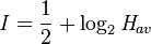
A tsunami cannot be precisely predicted, even if the magnitude and location of an earthquake is known. Geologists, oceanographers, and seismologists analyse each earthquake and based on many factors may or may not issue a tsunami warning. However, there are some warning signs of an impending tsunami, and automated systems can provide warnings immediately after an earthquake in time to save lives. One of the most successful systems uses bottom pressure sensors that are attached to buoys. The sensors constantly monitor the pressure of the overlying water column. This is deduced through the calculation:

where
P = the overlying pressure in newtons per metre square,
ρ = the density of the seawater= 1.1 x 10³ kg/m3,
g = the acceleration due to gravity= 9.8 m/s2 and
h = the height of the water column in metres.
Hence for a water column of 5,000 m depth the overlying pressure is equal to

or about 5500 tonnes-force per square metre.
Regions with a high tsunami risk typically use tsunami warning systems to warn the population before the wave reaches land. On the west coast of the United States, which is prone to Pacific Ocean tsunami, warning signs indicate evacuation routes. In Japan, the community is well-educated about earthquakes and tsunamis, and along the Japanese shorelines the tsunami warning signs are reminders of the natural hazards together with a network of warning sirens, typically at the top of the cliff of surroundings hills.
The Pacific Tsunami Warning System is based in Honolulu, Hawaiʻi. It monitors Pacific Ocean seismic activity. A sufficiently large earthquake magnitude and other information triggers a tsunami warning. While the subduction zones around the Pacific are seismically active, not all earthquakes generate tsunami. Computers assist in analysing the tsunami risk of every earthquake that occurs in the Pacific Ocean and the adjoining land masses.
As a direct result of the Indian Ocean tsunami, a re-appraisal of the tsunami threat for all coastal areas is being undertaken by national governments and the United Nations Disaster Mitigation Committee. A tsunami warning system is being installed in the Indian Ocean.Computer models can predict tsunami arrival, usually within minutes of the arrival time. Bottom pressure sensors relay information in real time. Based on these pressure readings and other seismic information and the seafloor's shape (bathymetry) and coastal topography, the models estimate the amplitude and surge height of the approaching tsunami. All Pacific Rim countries collaborate in the Tsunami Warning System and most regularly practice evacuation and other procedures. In Japan, such preparation is mandatory for government, local authorities, emergency services and the population.
Some zoologists hypothesise that some animal species have an ability to sense subsonic Rayleigh waves from an earthquake or a tsunami. If correct, monitoring their behavior could provide advance warning of earthquakes, tsunami etc. However, the evidence is controversial and is not widely accepted. There are unsubstantiated claims about the Lisbon quake that some animals escaped to higher ground, while many other animals in the same areas drowned. The phenomenon was also noted by media sources in Sri Lanka in the 2004 Indian Ocean earthquake. It is possible that certain animals (e.g., elephants) may have heard the sounds of the tsunami as it approached the coast. The elephants' reaction was to move away from the approaching noise. By contrast, some humans went to the shore to investigate and many drowned as a result.
Along the United States west coast, in addition to sirens, warnings are sent on television & radio via the National Weather Service, using the Emergency Alert System.
Tsunami Scales of Intensity and Magnitude
7:45 AM
As with earthquakes, several attempts have been made to set up scales of tsunami intensity or magnitude to allow comparison between different events.
Intensity scales
The first scales used routinely to measure the intensity of tsunami were the Sieberg-Ambraseys scale, used in the Mediterranean Sea and the Imamura-Iida intensity scale, used in the Pacific Ocean. The latter scale was modified by Soloviev, who calculated the Tsunami intensity I according to the formula
where Hav is the average wave height along the nearest coast. This scale, known as the Soloviev-Imamura tsunami intensity scale, is used in the global tsunami catalogues compiled by the NGDC/NOAA and the Novosibirsk Tsunami Laboratory as the main parameter for the size of the tsunami.
Magnitude scales
The first scale that genuinely calculated a magnitude for a tsunami, rather than an intensity at a particular location was the ML scale proposed by Murty & Loomis based on the potential energy. Difficulties in calculating the potential energy of the tsunami mean that this scale is rarely used. Abe introduced the tsunami magnitude scale Mt, calculated from,

Characteristics of Tsunami
7:43 AM
Tsunamis cause damage by two mechanisms: the smashing force of a wall of water travelling at high speed, and the destructive power of a large volume of water draining off the land and carrying all with it, even if the wave did not look large.
While everyday wind waves have a wavelength (from crest to crest) of about 100 metres (330 ft) and a height of roughly 2 metres (6.6 ft), a tsunami in the deep ocean has a wavelength of about 200 kilometres (120 mi). Such a wave travels at well over 800 kilometres per hour (500 mph), but owing to the enormous wavelength the wave oscillation at any given point takes 20 or 30 minutes to complete a cycle and has an amplitude of only about 1 metre (3.3 ft). This makes tsunamis difficult to detect over deep water. Ships rarely notice their passage.
As the tsunami approaches the coast and the waters become shallow, wave shoaling compresses the wave and its velocity slows below 80 kilometres per hour (50 mph). Its wavelength diminishes to less than 20 kilometres (12 mi) and its amplitude grows enormously. Since the wave still has the same very long period, the tsunami may take minutes to reach full height. Except for the very largest tsunamis, the approaching wave does not break, but rather appears like a fast-moving tidal bore. Open bays and coastlines adjacent to very deep water may shape the tsunami further into a step-like wave with a steep-breaking front.
When the tsunami's wave peak reaches the shore, the resulting temporary rise in sea level is termed run up. Run up is measured in metres above a reference sea level. A large tsunami may feature multiple waves arriving over a period of hours, with significant time between the wave crests. The first wave to reach the shore may not have the highest run up.
About 80% of tsunamis occur in the Pacific Ocean, but they are possible wherever there are large bodies of water, including lakes. They are caused by earthquakes, landslides, volcanic explosions, and bolides.
Tsunami Cause or Generation Mechanisms
7:34 AM

The principal generation mechanism or cause of a tsunami is the displacement of a substantial volume of water or perturbation of the sea. This displacement of water is usually attributed to either earthquakes, landslides, volcanic eruptions,glacier calvings or more rarely by meteorites and nuclear tests. The waves formed in this way are then sustained by gravity. Tides do not play any part in the generation of tsunamis.
Tsunami generated by seismicity
Tsunami can be generated when the sea floor abruptly deforms and vertically displaces the overlying water. Tectonic earthquakes are a particular kind of earthquake that are associated with the Earth's crustal deformation; when these earthquakes occur beneath the sea, the water above the deformed area is displaced from its equilibrium position. More specifically, a tsunami can be generated when thrust faults associated with convergent or destructive plate boundaries move abruptly, resulting in water displacement, owing to the vertical component of movement involved. Movement on normal faults will also cause displacement of the seabed, but the size of the largest of such events is normally too small to give rise to a significant tsunami.
 Tsunamis have a small amplitude (wave height) offshore, and a very long wavelength (often hundreds of kilometers long, whereas normal ocean waves have a wavelength of only 30 or 40 metres), which is why they generally pass unnoticed at sea, forming only a slight swell usually about 300 millimetres (12 in) above the normal sea surface. They grow in height when they reach shallower water, in a wave shoaling process described below. A tsunami can occur in any tidal state and even at low tide can still inundate coastal areas.
On April 1, 1946, a magnitude-7.8 (Richter Scale) earthquake occurred near the Aleutian Islands, Alaska. It generated a tsunami which inundated Hilo on the island of Hawai'i with a 14 metres (46 ft) high surge. The area where the earthquake occurred is where the Pacific Ocean floor is subducting (or being pushed downwards) under Alaska.
Examples of tsunami originating at locations away from convergent boundaries include Storegga about 8,000 years ago, Grand Banks 1929, Papua New Guinea 1998 (Tappin, 2001). The Grand Banks and Papua New Guinea tsunamis came from earthquakes which destabilized sediments, causing them to flow into the ocean and generate a tsunami. They dissipated before traveling transoceanic distances.
The cause of the Storegga sediment failure is unknown. Possibilities include an overloading of the sediments, an earthquake or a release of gas hydrates (methane etc.)
The 1960 Valdivia earthquake (Mw 9.5) (19:11 hrs UTC), 1964 Alaska earthquake (Mw 9.2), 2004 Indian Ocean earthquake (Mw 9.2) (00:58:53 UTC) and 2011 Tōhoku earthquake (Mw9.0) are recent examples of powerful megathrust earthquakes that generated tsunamis (known as teletsunamis) that can cross entire oceans. Smaller (Mw 4.2) earthquakes in Japan can trigger tsunamis (called local and regional tsunamis) that can only devastate nearby coasts, but can do so in only a few minutes.
In the 1950s, it was discovered that larger tsunamis than had previously been believed possible could be caused by giant landslides. These phenomena rapidly displace large water volumes, as energy from falling debris or expansion transfers to the water at a rate faster than the water can absorb. Their existence was confirmed in 1958, when a giant landslide in Lituya Bay, Alaska, caused the highest wave ever recorded, which had a height of 524 metres (over 1700 feet). The wave didn't travel far, as it struck land almost immediately. Two people fishing in the bay were killed, but another boat amazingly managed to ride the wave. Scientists named these waves megatsunami.
Scientists discovered that extremely large landslides from volcanic island collapses can generate megatsunamis that can cross oceans.
Etymology and History of Tsunami
7:32 AM
The term tsunami comes from the Japanese 津波, composed of the two kanji 津 (tsu) meaning "harbor" and 波 (nami), meaning "wave". (For the plural, one can either follow ordinary English practice and add an s, or use an invariable plural as in the Japanese.)
Tsunami are sometimes referred to as tidal waves. In recent years, this term has fallen out of favor, especially in the scientific community, because tsunami actually have nothing to do with tides. The once-popular term derives from their most common appearance, which is that of an extraordinarily high tidal bore. Tsunami and tides both produce waves of water that move inland, but in the case of tsunami the inland movement of water is much greater and lasts for a longer period, giving the impression of an incredibly high tide. Although the meanings of "tidal" include "resembling" or "having the form or character of" the tides, and the term tsunami is no more accurate because tsunami are not limited to harbours, use of the term tidal wave is discouraged by geologists and oceanographers.
There are only a few other languages that have an equivalent native word. In the Tamil language, the word is aazhi peralai. In the Acehnese language, it is ië beuna or alôn buluëk (Depending on the dialect. Note that in the fellow Austronesian language of Tagalog, a major language in the Philippines, alon means "wave".) On Simeulue island, off the western coast of Sumatra in Indonesia, in the Defayan language the word is smong, while in the Sigulai language it is emong.
As early as 426 B.C. the Greek historian Thucydides inquired in his book History of the Peloponnesian War about the causes of tsunami, and was the first to argue that ocean earthquakes must be the cause.
The cause, in my opinion, of this phenomenon must be sought in the earthquake. At the point where its shock has been the most violent the sea is driven back, and suddenly recoiling with redoubled force, causes the inundation. Without an earthquake I do not see how such an accident could happen.
The Roman historian Ammianus Marcellinus (Res Gestae 26.10.15-19) described the typical sequence of a tsunami, including an incipient earthquake, the sudden retreat of the sea and a following gigantic wave, after the 365 A.D. tsunami devastated Alexandria.
While Japan may have the longest recorded history of tsunamis, the sheer destruction caused by the 2004 earthquake and tsunami event mark it as the most devastating of its kind in modern times, killing around 230,000 people. The Sumatran region is not unused to tsunamis either, with earthquakes of varying magnitudes regularly occurring off the coast of the island.Tsunami
7:30 AM

A tsunami also called a tsunami wave train, and at one time incorrectly referred to as a tidal wave, is a series of water waves caused by the displacement of a large volume of a body of water, usually an ocean, though it can occur in large lakes. Tsunamis are a frequent occurrence in Japan; approximately 195 events have been recorded. Owing to the immense volumes of water and the high energy involved, tsunamis can devastate coastal regions.
Earthquakes, volcanic eruptions and other underwater explosions (including detonations of underwater nuclear devices), landslides glacier calvings and other mass movements, meteorite ocean impacts or similar impact events, and other disturbances above or below water all have the potential to generate a tsunami.
The Greek historian Thucydides was the first to relate tsunami to submarine earthquakes,[5][6] but the understanding of a tsunami's nature remained slim until the 20th century and is the subject of ongoing research. Many early geological, geographical, and oceanographic texts refer to tsunamis as "seismic sea waves."
Some meteorological conditions, such as deep depressions that cause tropical cyclones, can generate a storm surge, called a meteotsunami, which can raise tides several metres above normal levels. The displacement comes from low atmospheric pressure within the centre of the depression. As these storm surges reach shore, they may resemble (though are not) tsunamis, inundating vast areas of land.
Limnic Eruption Effect
7:12 AM
Once an eruption occurs, a large CO2 cloud forms above the lake and expands to the neighbouring region. Because CO2 is denser than air, it has a tendency to sink to the ground while pushing breathable air up. As a result, life forms that need to breathe oxygen suffocate once the CO2 cloud reaches them, as there is very little oxygen in the cloud. The CO2 can make human bodily fluids very acidic, potentially causing CO2 poisoning. As victims gasp for air they actually hurt themselves more by sucking in the CO2 gas.
At Lake Nyos, the gas cloud descended from the lake into a nearby village where it settled, killing nearly everyone. In this eruption, some people as far as 25 km (15.5 miles) from the lake died. A change in skin color on some bodies led scientists to think that the gas cloud may have contained a dissolved acid such as hydrogen chloride as well, but that hypothesis is disputed. Many victims were found with blisters on their skin. This is believed to have been caused by pressure ulcers, which likely formed from the low levels of oxygen present in the blood of those asphyxiated by the carbon dioxide. Thousands of cattle and wild animals were also asphyxiated, but no official counts were made. On the other hand, vegetation nearby was mostly unaffected except for that which grew immediately adjacent to the lake. There the vegetation was damaged or destroyed by a 5-meter (16.4 ft.) tsunami from the violent eruption.
Limnic Eruption Causes
7:10 AM
For a limnic eruption to occur, the lake must be nearly saturated with gas. In the two known cases, the major component was CO2, however, in Lake Kivu, scientists are concerned about the concentrations of methane gas as well. This CO2 may come from volcanic gas emitted from under the lake or from decomposition of organic material. Before a lake is saturated, it behaves like an unopened carbonated beverage (soft drink): the CO2 is dissolved in the water. In both the lake and the soft drink, CO2 dissolves much more readily at higher pressure. This is why bubbles in a can of soda only form after the drink is open; the pressure is released and the CO2 comes out of solution. In the case of lakes, the bottom is at a much higher pressure; the deeper it is, the higher the pressure at the bottom. This means that huge amounts of CO2 can be dissolved in large, deep lakes. Also, CO2 dissolves more readily in cooler water, such as that at the bottom of a lake. A small rise in water temperature can lead to the release of a large amount of CO2.
Once the lake is saturated with CO2, it is very unstable. A trigger is all that is needed to set off an eruption. In the case of the 1986 eruption at Lake Nyos, landslides were the suspected triggers, but an actual volcanic eruption, an earthquake, or even wind and rain storms are other possible triggers. In any case, the trigger pushes some of the saturated water higher in the lake, where the pressure is insufficient to keep the CO2 in solution. Bubbles start forming and the water is lifted even higher in the lake (buoyancy), where even more of the CO2 comes out of solution. This process forms a column of gas. At this point the water at the bottom of this column is pulled up by suction, and it too loses its CO2 in a runaway process. This eruption pours CO2 into the air and can also displace water to form a tsunami.
There are several reasons this type of eruption is very rare. First, there must be a source of the CO2, so only regions with volcanic activity are at risk. Second, temperate lakes, such as North America's Great Lakes, turn over each spring and fall as a result of seasonal air temperature changes, mixing water from the bottom and top of the lake, so CO2 that builds up at the bottom of the lake is brought to the top where the pressure is too low for it to stay in solution and it escapes into the atmosphere. Finally, a lake must be quite deep to have enough pressure to dissolve large volumes of CO2. So only in deep, stable, tropical, volcanic lakes such as Lake Nyos are limnic eruptions possible.
Limnic Eruption - Lake Overturn
7:07 AM

A limnic eruption or lake overturn, is a rare type of natural disaster in which carbon dioxide (CO2) suddenly erupts from deep lake water, suffocating wildlife, livestock and humans. Such an eruption may also cause tsunamis in the lake as the rising CO2 displaces water. Scientists believe landslides, volcanic activity, or explosions can trigger such an eruption. Lakes in which such activity occurs may be known as limnically active lakes or exploding lakes. Some features of limnically active lakes include:
- CO2-saturated incoming water
- A cool lake bottom indicating an absence of direct volcanic interaction with lake waters
- An upper and lower thermal layer with differing CO2 saturations
- Proximity to areas with volcanic activity
List of Floods
7:48 AM