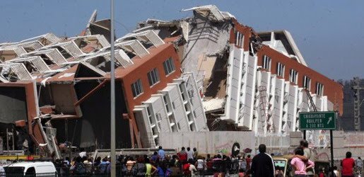
Earthquake
An earthquake (also known as a quake, tremor or temblor) is the result of a sudden release of energy in the Earth's crust that creates seismic waves.
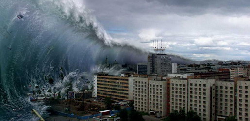
Tsunami
A tsunami also called a tsunami wave train, and at one time incorrectly referred to as a tidal wave, is a series of water waves caused by the displacement of a large volume of a body of water, usually an ocean, though it can occur in large lakes.
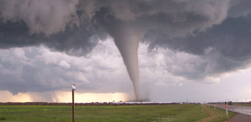
Tornado
A tornado (often referred to as a twister or, erroneously, a cyclone) is a violent, dangerous, rotating column of air that is in contact with both the surface of the earth and a cumulonimbus cloud or, in rare cases, the base of a cumulus cloud.
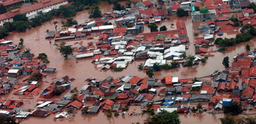
Floods
A flood is an overflow of an expanse of water that submerges land. The EU Floods directive defines a flood as a temporary covering by water of land not normally covered by water
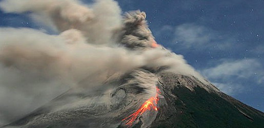
Volcanic Eruptions
Volcanoes can cause widespread destruction and consequent disaster through several ways. The effects include the volcanic eruption itself that may cause harm following the explosion of the volcano or the fall of rock.
Tsunami 1950–2000
6:16 AM
1952: Severo-Kurilsk, Kuril Islands, USSR
The November 5, 1952 tsunami killed 2,336 on the Kuril Islands, USSR.
1958: Lituya Bay, Alaska, USA
On July 9, 1958, an earthquake caused a megatsunami to reach a height taller than the Empire State Building, measuring over 520 metres (1,706 ft), killing two.
1960: Valdivia, Chile
The magnitude-9.5 Great Chilean Earthquake of May 22, 1960 is the strongest earthquake ever recorded. Its epicenter, off the coast of South Central Chile, generated one of the most destructive tsunami of the 20th Century. It also caused a volcanic eruption.
It spread across the entire Pacific Ocean, with waves measuring up to 25 meters high. The first tsunami arrived at Hilo approximately 14.8 hrs after it originated off the coast of South Central Chile. The highest wave at Hilo Bay was measured at around 10.7 m (35 ft). 61 lives were lost allegedly due to people's failure to heed warning sirens.
Almost 22 hours after the quake, the waves hit the ill-fated Sanriku coast of Japan, reaching up to 3 m above high tide, and killed 142 people. Up to 6,000 people died in total worldwide due to the earthquake and tsunami.
1963: Vajont Dam, Monte Toc, Italy
The Vajont Dam was completed in 1961 under Monte Toc, 100 km north of Venice, Italy. At 262 metres, it was one of the highest dams in the world. On October 9, 1963 an enormous landslide of about 260 million cubic metres of forest, earth, and rock, fell into the reservoir at up to 110 km per hour (68 mph). The resulting displacement of water caused 50 million cubic metres of water to overtop the dam in a 250-metre high megatsunami wave. The flooding destroyed the villages of Longarone, Pirago, Rivalta, Villanova and Faè, killing 1,450 people. Almost 2,000 people (some sources report 1,909) perished in total.1964: Niigata, Japan
The 1964 Niigata earthquake in Japan killed 28 people, and liquefacted whole apartment buildings. A subsequent tsunami destroyed the port of Niigata city.
1964: Alaska, USA
After the magnitude 9.2 Good Friday Earthquake, tsunamis struck Alaska, British Columbia, California, and coastal Pacific Northwest towns, killing 121 people. The waves were up to 100 feet tall, and killed 11 people as far away as Crescent City, California. This happened on March 27, 1964. The incident was covered in Dennis Powers' The Raging Sea: The Powerful Account of the Worst Tsunami in U.S. History (ISBN 0806526823).
1976: Moro Gulf, Mindanao, Philippines
On August 16, 1976 at 12:11 A.M., a devastating earthquake of 7.9 hit the island of Mindanao, Philippines. It created a tsunami that devastated more than 700 km of coastline bordering Moro Gulf in the North Celebes Sea. An estimated number of victims for this tragedy left 5,000 dead, 2,200 missing or presumed dead, more than 9,500 injured and a total of 93,500 people were left homeless. It devastated the cities of Cotabato, Pagadian, and Zamboanga, and the and provinces of Basilan, Lanao del Norte, Lanao del Sur, Maguindanao, Sultan Kudarat, Sulu, and Zamboanga del Sur.
1979: Tumaco, Colombia
A magnitude 7.9 earthquake occurred on December 12, 1979 at 7:59:4.3 UTC along the Pacific coast of Colombia and Ecuador. The earthquake and the resulting tsunami caused the destruction of at least six fishing villages and the death of hundreds of people in the Colombian Department of Nariño. The earthquake was felt in Bogotá, Cali, Popayán, Buenaventura, and several other cities and towns in Colombia and in Guayaquil, Esmeraldas, Quito, and other parts of Ecuador. When the tsunami hit the coast, it caused huge destruction in the city of Tumaco, as well as in the small towns of El Charco, San Juan, Mosquera, and Salahonda on the Pacific coast of Colombia. The total number of victims of this tragedy was 259 dead, 798 wounded and 95 missing or presumed dead.
1980: Spirit Lake, Washington, USA
On May 18, 1980, the upper 460m (1400 ft) of Mount St. Helens had failed, in the course of a major eruption of that volcano, causing a major landslide. One lobe of the landslide surged onto the nearby Spirit Lake, creating a megatsunami of 260 meters high.
1983: Sea of Japan
On May 26, 1983 at 11:59:57 local time, a magnitude-7.7 earthquake occurred in the Sea of Japan, about 100 km west of the coast of Noshiro in Akita Prefecture, Japan. Out of the 107 fatalities, all but four were killed by the resulting tsunami, which struck communities along the coast, especially Aomori and Akita Prefectures and the east coast of Noto Peninsula. Footage of the tsunami hitting the fishing harbor of Wajima on Noto Peninsula was broadcast on TV. The waves exceeded 10 meters in some areas. Three of the fatalities were along the east coast of South Korea (whether North Korea was affected is not known). The tsunami also hit Okushiri Island, the site of a more deadly tsunami 10 years later.
1993: Okushiri, Hokkaido, Japan
A devastating tsunami wave occurred along the coasts of Hokkaidō in Japan as a result of a magnitude 7.8 earthquake, 80 miles (130 km) offshore, on July 12, 1993.
Within minutes, the Japan Meteorological Agency issued a tsunami warning that was broadcast on NHK in English and Japanese (archived at NHK library). However, it was too late for Okushiri, a small island near the epicenter, which was struck with extremely big waves, some reaching 30 meters, within two to five minutes of the quake. Aonae, a village on a low-lying peninsula at the southern tip of the island, was devastated over the course of the following hour by 13 waves of over two meters’ height arriving from multiple directions, including waves that had bounced back off Hokkaidō—despite being surrounded by tsunami barriers. Of 250 people killed as a result of the quake, 197 were victims of the series of tsunamis that hit Okushiri; the waves also caused deaths on the coast of Hokkaidō. While many residents, remembering the 1983 tsunami (see above), survived by quickly evacuating on foot to higher ground, it is thought that many others underestimated how soon the waves would arrive (the 1983 tsunami took 17 minutes to hit Okushiri) and were killed as they attempted to evacuate by car along the village’s narrow lanes. The highest wave of the tsunami was a staggering 31 meters (102 ft) high.
1998: Papua New Guinea
On 17 July 1998, a Papua New Guinea tsunami killed approximately 2,200 people. A 7.1-magnitude earthquake 24 km offshore was followed within 11 minutes by a tsunami about 15 metres tall. The tsunami was generated by an undersea landslide, which was triggered by the earthquake. The magnitude of the earthquake was too low to generate a tsunami. The villages of Arop and Warapu were destroyed.