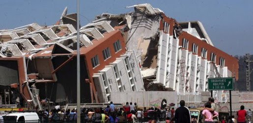
Earthquake
An earthquake (also known as a quake, tremor or temblor) is the result of a sudden release of energy in the Earth's crust that creates seismic waves.
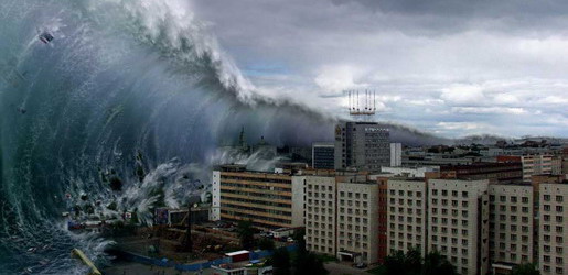
Tsunami
A tsunami also called a tsunami wave train, and at one time incorrectly referred to as a tidal wave, is a series of water waves caused by the displacement of a large volume of a body of water, usually an ocean, though it can occur in large lakes.
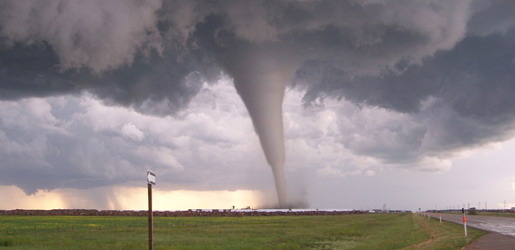
Tornado
A tornado (often referred to as a twister or, erroneously, a cyclone) is a violent, dangerous, rotating column of air that is in contact with both the surface of the earth and a cumulonimbus cloud or, in rare cases, the base of a cumulus cloud.
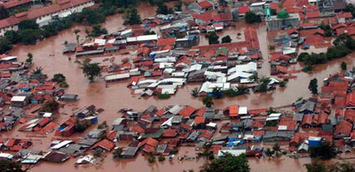
Floods
A flood is an overflow of an expanse of water that submerges land. The EU Floods directive defines a flood as a temporary covering by water of land not normally covered by water
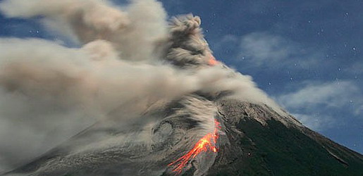
Volcanic Eruptions
Volcanoes can cause widespread destruction and consequent disaster through several ways. The effects include the volcanic eruption itself that may cause harm following the explosion of the volcano or the fall of rock.
Tsunami 2000s
6:19 AM
2004: Indian Ocean
The 2004 Indian Ocean earthquake, which had a moment magnitude of 9.1–9.3, triggered a series of lethal tsunamis on December 26, 2004, that killed approximately 230,210 people (including 168,000 in Indonesia alone), making it the deadliest tsunami as well as one of the deadliest natural disasters in recorded history. It was also caused by the third largest earthquake in recorded history. The initial surge was measured at a height of approximately 33 meters (108 ft), making it the largest earthquake-generated tsunami in recorded history. The tsunami killed people over an area ranging from the immediate vicinity of the quake in Indonesia, Thailand, and the north-western coast of Malaysia, to thousands of kilometres away in Bangladesh, India, Sri Lanka, the Maldives, and even as far away as Somalia, Kenya, and Tanzania in eastern Africa. This trans-Indian Ocean tsunami is an example of a teletsunami, which can travel vast distances across the open ocean. In this case, it is an ocean-wide tsunami.Unlike in the Pacific Ocean, there was no organized alert service covering the Indian Ocean. This was in part due to the absence of major tsunami events since 1883 (the Krakatoa eruption, which killed 36,000 people). In light of the 2004 Indian Ocean tsunami, UNESCO and other world bodies have called for an international tsunami monitoring system.
2006: South of Java Island
A 7.7 magnitude earthquake rocked the Indian Ocean seabed on July 17, 2006, 200 km south of Pangandaran, a beautiful beach famous to surfers for its perfect waves. This earthquake triggered tsunamis which height varied from 2 meters at Cilacap to 6 meters at Cimerak beach, where it swept away and flattened buildings as far as 400 meters away from the coastline. More than 800 people were reported missing or dead.
2006: Kuril Islands
On 15 November 2006, a magnitude 8.3 earthquake occurred off the coast near the Kuril Islands. In spite of the quake's large 8.3 magnitude, a relatively small tsunami was generated. The small tsunami was recorded or observed in Japan and at distant locations throughout the Pacific.
2007: Solomon Islands
On April 24, 2007, a powerful magnitude 8.1 (initially 7.6) earthquake hit the East Pacific region about 40 km (25 miles) northwest of the Solomon Islands at 7:39 a.m., resulting in a tsunami that was up to 5 m (17 feet) tall. The wave, which struck the coast of Solomon Islands (mainly Gizo), triggered region-wide tsunami warnings and watches extending from Japan to New Zealand to Hawaii and the eastern seaboard of Australia. The tsunami that followed the earthquake killed 52 people. Dozens more have been injured with entire towns inundated by the sweeping water which travelled 300 meters inland in some places. Simbo, Choiseul and Ranunga islands were also affected. A state of national emergency was declared for the Solomon Islands. On the island of Choiseul, a wall of water reported to be 9.1 m (30 feet) high swept almost 400 meters inland destroying everything in its path. Officials estimate that the tsunami displaced more than 5000 residents all over the archipelago.
2007: Niigata, Japan
On 16 July 2007, a strong earthquake struck northwestern Japan, causing a fire and minor radioactive water leak at one of the world's most powerful nuclear power plants. At least seven people were killed and hundreds injured. Japan's Meteorological Agency measured the quake at 6.8 on the richter scale and sending aftershocks of 6.6. The U.S. Geological Survey, which monitors quakes around the world, said the initial quake registered 6.7. A tsunami watch was issued along the Sea of Japan. The predicted height of the tsunami was estimated to be 50 cm (20 inches). That earthquake sparked only a few small tsunamis, growing to be no more than about 20 cm (8 inches) tall. However, the 1964 quake and tsunami north of the current one destroyed the port of the city of Niigata.
2010: Chile
The seismic event in the southern Pacific produced waves measuring 1.8–9 meters along the Sanriku Coastline of northeastern Honshu in Japan.2011: New Zealand
On February 22, 2011, a 6.3 magnitude earthquake hit the Canterbury Region of the South Island, New Zealand. Some 200 kilometres (120 mi) away from the earthquake's epicenter, around 30 million tonnes of ice tumbled off the Tasman Glacier into Tasman Lake, producing a series of 3.5 m (11 ft) high tsunami waves, which hit tourist boats in the lake.
2011: Pacific coast of Japan
On March 11, 2011, off the Pacific coast of Japan, a 9.0 magnitude earthquake produced a tsunami 33 feet (10 m) high along Japan's northeastern coast. The wave caused widespread devastation, with an official count of more than 25,000 people confirmed to be killed/missing. The highest tsunami which was recorded at Ryōri Bay, Ōfunato, reached a total height of 97 feet (30 m). In addition the tsunami precipitated a hydrogen explosion and a suspected partial nuclear meltdown at the Fukushima I Nuclear Power Plant. Tsunami warnings were issued to the entire Pacific Rim.