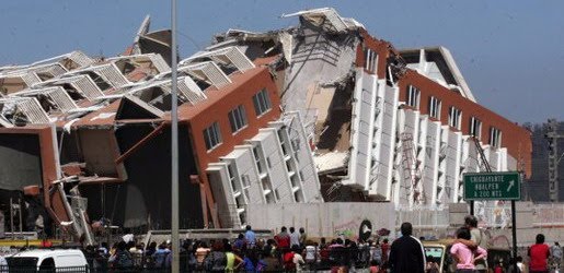
Earthquake
An earthquake (also known as a quake, tremor or temblor) is the result of a sudden release of energy in the Earth's crust that creates seismic waves.
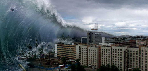
Tsunami
A tsunami also called a tsunami wave train, and at one time incorrectly referred to as a tidal wave, is a series of water waves caused by the displacement of a large volume of a body of water, usually an ocean, though it can occur in large lakes.
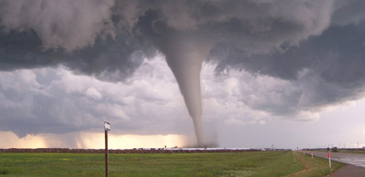
Tornado
A tornado (often referred to as a twister or, erroneously, a cyclone) is a violent, dangerous, rotating column of air that is in contact with both the surface of the earth and a cumulonimbus cloud or, in rare cases, the base of a cumulus cloud.
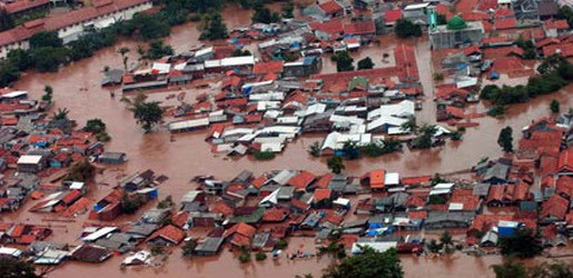
Floods
A flood is an overflow of an expanse of water that submerges land. The EU Floods directive defines a flood as a temporary covering by water of land not normally covered by water
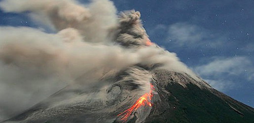
Volcanic Eruptions
Volcanoes can cause widespread destruction and consequent disaster through several ways. The effects include the volcanic eruption itself that may cause harm following the explosion of the volcano or the fall of rock.
Deadliest Earthquakes on Record
7:33 AM
| Rank | Name | Date | Location | Fatalities | Mag. |
|---|---|---|---|---|---|
| 1 | "Shaanxi" | January 23, 1556 | Shaanxi, China | 820,000– 830,000 (est.) | 8.0 (est.) |
| 2 | "Tangshan" | July 28, 1976 | Tangshan, China | 242,419– 779,000 | 7.5-7.8 |
| 3 | "Antioch" | May 21, 525 | Antioch, Turkey (then Byzantine Empire) | 250,000 | 8.0 (est.) |
| 4 | "Gansu" | December 16, 1920 | Ningxia–Gansu, China | 235,502 | 7.8 |
| 5 | "Indian Ocean" | December 26, 2004 | Indian Ocean, Sumatra, Indonesia | 230,210+ | 9.1–9.3 |
| 6 | "Aleppo" | October 11, 1138 | Aleppo, Syria | 230,000 | Unknown |
| 7 | "Haiti" | January 12, 2010 | Haiti | 222,570 (Haitian sources) 50,000-92,000 (non-Haitian sources) | 7.0 |
| 8 | "Damghan" | December 22, 856 | Damghan, Iran | 200,000 (est) | 7.9 (est.) |
| 9 | "Ardabil" | March 22, 893 | Ardabil, Iran | 150,000 (est) | Unknown |
| 10 | "Great Kantō" | September 1, 1923 | Kantō region, Japan | 142,000 | 7.9 |
| 11 | "Messina" | December 28, 1908 | Messina, Italy | 123,000 | 7.1 |
| 12 | "Ashgabat" | October 6, 1948 | Ashgabat, Turkmenistan | 110,000 | 7.3 |
| 13 | "Genroku" | December 31, 1703 | Edo, Japan | 108,800+ | Unknown |
| 14 | "Lisbon" | November 1, 1755 | Lisbon, Portugal | 10,000– 100,000 | 8.7-9.0 (est.) |
Largest Earthquakes by Magnitude
7:30 AM
Listed the earthquake with moment magnitude scale or Richter magnitude scale 8.5 and above. This list may be biased towards recent years due to the development and widespread deployment of seismometers. Records detailed enough to make magnitude estimates were not generally available before 1900.
Major Earthquakes
7:28 AM
One of the most devastating earthquakes in recorded history occurred on 23 January 1556 in the Shaanxi province, China, killing more than 830,000 people (1556 Shaanxi earthquake). Most of the population in the area at the time lived in yaodongs, artificial caves in loess cliffs, many of which collapsed during the catastrophe with great loss of life. The 1976 Tangshan earthquake, with death toll estimated to be between 240,000 to 655,000, is believed to be the largest earthquake of the 20th century by death toll.
The largest earthquake that has been measured on a seismograph reached 9.5 magnitude, occurring on 22 May 1960. Its epicenter was near Cañete, Chile. The energy released was approximately twice that of the next most powerful earthquake, the Good Friday Earthquake, which was centered in Prince William Sound, Alaska. The ten largest recorded earthquakes have all been megathrust earthquakes; however, of these ten, only the 2004 Indian Ocean earthquake is simultaneously one of the deadliest earthquakes in history.
Earthquakes that caused the greatest loss of life, while powerful, were deadly because of their proximity to either heavily populated areas or the ocean, where earthquakes often create tsunamis that can devastate communities thousands of kilometers away. Regions most at risk for great loss of life include those where earthquakes are relatively rare but powerful, and poor regions with lax, unenforced, or nonexistent seismic building codes.
Effects of Earthquakes
7:26 AM
The effects of earthquakes include, but are not limited to, the following:
Shaking and ground rupture
Shaking and ground rupture are the main effects created by earthquakes, principally resulting in more or less severe damage to buildings and other rigid structures. The severity of the local effects depends on the complex combination of the earthquake magnitude, the distance from the epicenter, and the local geological and geomorphological conditions, which may amplify or reduce wave propagation. The ground-shaking is measured by ground acceleration.
Specific local geological, geomorphological, and geostructural features can induce high levels of shaking on the ground surface even from low-intensity earthquakes. This effect is called site or local amplification. It is principally due to the transfer of the seismic motion from hard deep soils to soft superficial soils and to effects of seismic energy focalization owing to typical geometrical setting of the deposits.
Ground rupture is a visible breaking and displacement of the Earth's surface along the trace of the fault, which may be of the order of several metres in the case of major earthquakes. Ground rupture is a major risk for large engineering structures such as dams, bridges and nuclear power stations and requires careful mapping of existing faults to identify any likely to break the ground surface within the life of the structure.
Landslides and avalanches
Earthquakes, along with severe storms, volcanic activity, coastal wave attack, and wildfires, can produce slope instability leading to landslides, a major geological hazard. Landslide danger may persist while emergency personnel are attempting rescue.
Fires
Earthquakes can cause fires by damaging electrical power or gas lines. In the event of water mains rupturing and a loss of pressure, it may also become difficult to stop the spread of a fire once it has started. For example, more deaths in the 1906 San Francisco earthquake were caused by fire than by the earthquake itself.
Soil liquefaction
Soil liquefaction occurs when, because of the shaking, water-saturated granular material (such as sand) temporarily loses its strength and transforms from a solid to a liquid. Soil liquefaction may cause rigid structures, like buildings and bridges, to tilt or sink into the liquefied deposits. This can be a devastating effect of earthquakes. For example, in the 1964 Alaska earthquake, soil liquefaction caused many buildings to sink into the ground, eventually collapsing upon themselves.
Tsunami
Tsunamis are long-wavelength, long-period sea waves produced by the sudden or abrupt movement of large volumes of water. In the open ocean the distance between wave crests can surpass 100 kilometers (62 miles), and the wave periods can vary from five minutes to one hour. Such tsunamis travel 600-800 kilometers per hour (373–497 miles per hour), depending on water depth. Large waves produced by an earthquake or a submarine landslide can overrun nearby coastal areas in a matter of minutes. Tsunamis can also travel thousands of kilometers across open ocean and wreak destruction on far shores hours after the earthquake that generated them.Ordinarily, subduction earthquakes under magnitude 7.5 on the Richter scale do not cause tsunamis, although some instances of this have been recorded. Most destructive tsunamis are caused by earthquakes of magnitude 7.5 or more.
Floods
A flood is an overflow of any amount of water that reaches land. Floods occur usually when the volume of water within a body of water, such as a river or lake, exceeds the total capacity of the formation, and as a result some of the water flows or sits outside of the normal perimeter of the body. However, floods may be secondary effects of earthquakes, if dams are damaged. Earthquakes may cause landslips to dam rivers, which collapse and cause floods.
The terrain below the Sarez Lake in Tajikistan is in danger of catastrophic flood if the landslide dam formed by the earthquake, known as the Usoi Dam, were to fail during a future earthquake. Impact projections suggest the flood could affect roughly 5 million people.
Tidal forces
Research work has shown a robust correlation between small tidally induced forces and non-volcanic tremor activity.
Human impacts
An earthquake may cause injury and loss of life, road and bridge damage, general property damage, and collapse or destabilization (potentially leading to future collapse) of buildings. The aftermath may bring disease, lack of basic necessities, higher insurance premiums, Earthquakes can also cause volcanic eruptions, bringing further problems.
Measuring and Locating Earthquakes
7:25 AM
Earthquakes can be recorded by seismometers up to great distances, because seismic waves travel through the whole Earth's interior. The absolute magnitude of a quake is conventionally reported by numbers on the Moment magnitude scale (formerly Richter scale, magnitude 7 causing serious damage over large areas), whereas the felt magnitude is reported using the modified Mercalli intensity scale (intensity II-XII).
Every tremor produces different types of seismic waves, which travel through rock with different velocities:
- Longitudinal P-waves (shock- or pressure waves)
- Transverse S-waves (both body waves)
- Surface waves—(Rayleigh and Love waves)
Propagation velocity of the seismic waves ranges from approx. 3 km/s up to 13 km/s, depending on the density and elasticity of the medium. In the Earth's interior the shock- or P waves travel much faster than the S waves (approx. relation 1.7 : 1). The differences in travel time from the epicentre to the observatory are a measure of the distance and can be used to image both sources of quakes and structures within the Earth. Also the depth of the hypocenter can be computed roughly.
In solid rock P-waves travel at about 6 to 7 km per second; the velocity increases within the deep mantle to ~13 km/s. The velocity of S-waves ranges from 2–3 km/s in light sediments and 4–5 km/s in the Earth's crust up to 7 km/s in the deep mantle. As a consequence, the first waves of a distant earth quake arrive at an observatory via the Earth's mantle.
Rule of thumb: On the average, the kilometer distance to the earthquake is the number of seconds between the P and S wave times 8. Slight deviations are caused by inhomogeneities of subsurface structure. By such analyses of seismograms the Earth's core was located in 1913 by Beno Gutenberg.
Earthquakes are not only categorized by their magnitude but also by the place where they occur. The world is divided into 754 Flinn-Engdahl regions (F-E regions), which are based on political and geographical boundaries as well as seismic activity. More active zones are divided into smaller F-E regions whereas less active zones belong to larger F-E regions.
Size and Frequency of Earthquake
7:23 AM
There are around 500,000 earthquakes each year. About 100,000 of these can actually be felt. Minor earthquakes occur nearly constantly around the world in places like California and Alaska in the U.S., as well as in Guatemala. Chile, Peru, Indonesia, Iran, Pakistan, the Azores in Portugal, Turkey, New Zealand, Greece, Italy, and Japan, but earthquakes can occur almost anywhere, including New York City, London, and Australia. Larger earthquakes occur less frequently, the relationship being exponential; for example, roughly ten times as many earthquakes larger than magnitude 4 occur in a particular time period than earthquakes larger than magnitude 5. In the (low seismicity) United Kingdom, for example, it has been calculated that the average recurrences are: an earthquake of 3.7 - 4.6 every year, an earthquake of 4.7 - 5.5 every 10 years, and an earthquake of 5.6 or larger every 100 years. This is an example of the Gutenberg-Richter law.
The number of seismic stations has increased from about 350 in 1931 to many thousands today. As a result, many more earthquakes are reported than in the past, but this is because of the vast improvement in instrumentation, rather than an increase in the number of earthquakes. The United States Geological Survey estimates that, since 1900, there have been an average of 18 major earthquakes (magnitude 7.0-7.9) and one great earthquake (magnitude 8.0 or greater) per year, and that this average has been relatively stable. In recent years, the number of major earthquakes per year has decreased, though this is probably a statistical fluctuation rather than a systematic trend. More detailed statistics on the size and frequency of earthquakes is available from the United States Geological Survey (USGS). Alternatively, some scientists suggest that the recent increase in major earthquakes could be explained by a cyclical pattern of periods of intense tectonic activity, interspersed with longer periods of low-intensity. However, accurate recordings of earthquakes only began in the early 1900s, so it is too early to categorically state that this is the case.
Most of the world's earthquakes (90%, and 81% of the largest) take place in the 40,000-km-long, horseshoe-shaped zone called the circum-Pacific seismic belt, known as the Pacific Ring of Fire, which for the most part bounds the Pacific Plate. Massive earthquakes tend to occur along other plate boundaries, too, such as along the Himalayan Mountains.
With the rapid growth of mega-cities such as Mexico City, Tokyo and Tehran, in areas of high seismic risk, some seismologists are warning that a single quake may claim the lives of up to 3 million peopleEarthquake Clusters
7:23 AM
Aftershocks
An aftershock is an earthquake that occurs after a previous earthquake, the mainshock. An aftershock is in the same region of the main shock but always of a smaller magnitude. If an aftershock is larger than the main shock, the aftershock is redesignated as the main shock and the original main shock is redesignated as a foreshock. Aftershocks are formed as the crust around the displaced fault plane adjusts to the effects of the main shock.
Earthquake swarms
Earthquake swarms are sequences of earthquakes striking in a specific area within a short period of time. They are different from earthquakes followed by a series of aftershocks by the fact that no single earthquake in the sequence is obviously the main shock, therefore none have notable higher magnitudes than the other. An example of an earthquake swarm is the 2004 activity at Yellowstone National Park.
Earthquake storms
Rupture Dynamics Eartquake
7:22 AM
Rupture propagation is generally modelled using a fracture mechanics approach, likening the rupture to a propagating mixed mode shear crack. The rupture velocity is a function of the fracture energy in the volume around the crack tip, increasing with decreasing fracture energy. The velocity of rupture propagation is orders of magnitude faster than the displacement velocity across the fault. Earthquake ruptures typically propagate at velocities that are in the range 70–90 % of the S-wave velocity and this is independent of earthquake size. A small subset of earthquake ruptures appear to have propagated at speeds greater than the S-wave velocity. These supershear earthquakes have all been observed during large strike-slip events. The unusually wide zone of coseismic damage caused by the 2001 Kunlun earthquake has been attributed to the effects of the sonic boom developed in such earthquakes. Some earthquake ruptures travel at unusually low velocities and are referred to as slow earthquakes. A particularly dangerous form of slow earthquake is the tsunami earthquake, observed where the relatively low felt intensities, caused by the slow propagation speed of some great earthquakes, fail to alert the population of the neighbouring coast, as in the 1896 Meiji-Sanriku earthquake.
Earthquakes and volcanic activity
7:21 AM
Shallow-Focus and Deep-Focus Earthquakes
7:20 AM
Earthquakes away From Plate Boundaries
7:19 AM
Where plate boundaries occur within continental lithosphere, deformation is spread out over a much larger area than the plate boundary itself. In the case of the San Andreas fault continental transform, many earthquakes occur away from the plate boundary and are related to strains developed within the broader zone of deformation caused by major irregularities in the fault trace (e.g., the “Big bend” region). The Northridge earthquake was associated with movement on a blind thrust within such a zone. Another example is the strongly oblique convergent plate boundary between the Arabian and Eurasian plates where it runs through the northwestern part of the Zagros mountains. The deformation associated with this plate boundary is partitioned into nearly pure thrust sense movements perpendicular to the boundary over a wide zone to the southwest and nearly pure strike-slip motion along the Main Recent Fault close to the actual plate boundary itself. This is demonstrated by earthquake focal mechanisms.
All tectonic plates have internal stress fields caused by their interactions with neighbouring plates and sedimentary loading or unloading (e.g. deglaciation). These stresses may be sufficient to cause failure along existing fault planes, giving rise to intraplate earthquakes.
Earthquake Fault Types
7:17 AM
There are three main types of fault that may cause an earthquake: normal, reverse (thrust) and strike-slip.
Normal and reverse faulting are examples of dip-slip, where the displacement along the fault is in the direction of dip and movement on them involves a vertical component. Normal faults occur mainly in areas where the crust is being extended such as a divergent boundary. Reverse faults occur in areas where the crust is being shortened such as at a convergent boundary. Strike-slip faults are steep structures where the two sides of the fault slip horizontally past each other; transform boundaries are a particular type of strike-slip fault. Many earthquakes are caused by movement on faults that have components of both dip-slip and strike-slip; this is known as oblique slip. Reverse faults, particularly those along convergent plate boundaries are associated with the most powerful earthquakes, including almost all of those of magnitude 8 or more. Strike-slip faults, particularly continental transforms can produce major earthquakes up to about magnitude 8. Earthquakes associated with normal faults are generally less than magnitude 7.
Naturally Occurring Earthquakes
7:14 AM
Tectonic earthquakes occur anywhere in the earth where there is sufficient stored elastic strain energy to drive fracture propagation along a fault plane. The sides of a fault move past each other smoothly and aseismically only if there are no irregularities or asperities along the fault surface that increase the frictional resistance. Most fault surfaces do have such asperities and this leads to a form of stick-slip behaviour. Once the fault has locked, continued relative motion between the plates leads to increasing stress and therefore, stored strain energy in the volume around the fault surface. This continues until the stress has risen sufficiently to break through the asperity, suddenly allowing sliding over the locked portion of the fault, releasing the stored energy. This energy is released as a combination of radiated elastic strain seismic waves, frictional heating of the fault surface, and cracking of the rock, thus causing an earthquake. This process of gradual build-up of strain and stress punctuated by occasional sudden earthquake failure is referred to as the elastic-rebound theory. It is estimated that only 10 percent or less of an earthquake's total energy is radiated as seismic energy. Most of the earthquake's energy is used to power the earthquake fracture growth or is converted into heat generated by friction. Therefore, earthquakes lower the Earth's available elastic potential energy and raise its temperature, though these changes are negligible compared to the conductive and convective flow of heat out from the Earth's deep interior.
What is Earthquake?
7:09 AM

An earthquake (also known as a quake, tremor or temblor) is the result of a sudden release of energy in the Earth's crust that creates seismic waves. The seismicity or seismic activity of an area refers to the frequency, type and size of earthquakes experienced over a period of time. Earthquakes are measured using observations from seismometers. The moment magnitude (or the partly obsolete Richter magnitude, numerically similar over the range of validity of the Richter scale) of an earthquake is conventionally reported, with magnitude 3 or lower earthquakes being mostly almost imperceptible and magnitude 7 and over potentially causing serious damage over large areas, depending on their depth. The largest earthquakes in historic times have been of magnitude slightly over 9, although there is no limit to the possible magnitude. The most recent large earthquake of magnitude 9.0 or larger was a 9.0 magnitude earthquake in Japan in 2011 (as of March 2011), and it was the largest Japanese earthquake since records began. Intensity of shaking is measured on the modified Mercalli scale. The shallower an earthquake, the more damage to structures it causes, all else being equal.
At the Earth's surface, earthquakes manifest themselves by shaking and sometimes displacement of the ground. When a large earthquake epicenter is located offshore, the seabed may be displaced sufficiently to cause a tsunami. Earthquakes can also trigger landslides, and occasionally volcanic activity.
In its most general sense, the word earthquake is used to describe any seismic event—whether natural or caused by humans—that generates seismic waves. Earthquakes are caused mostly by rupture of geological faults, but also by other events such as volcanic activity, landslides, mine blasts, and nuclear tests. An earthquake's point of initial rupture is called its focus or hypocenter. The epicenter is the point at ground level directly above the hypocenter.