Earthquake
An earthquake (also known as a quake, tremor or temblor) is the result of a sudden release of energy in the Earth's crust that creates seismic waves.

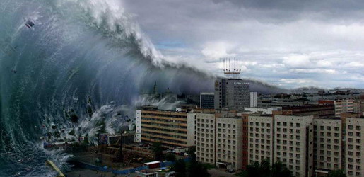
Tsunami
A tsunami also called a tsunami wave train, and at one time incorrectly referred to as a tidal wave, is a series of water waves caused by the displacement of a large volume of a body of water, usually an ocean, though it can occur in large lakes.
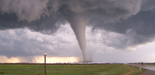
Tornado
A tornado (often referred to as a twister or, erroneously, a cyclone) is a violent, dangerous, rotating column of air that is in contact with both the surface of the earth and a cumulonimbus cloud or, in rare cases, the base of a cumulus cloud.
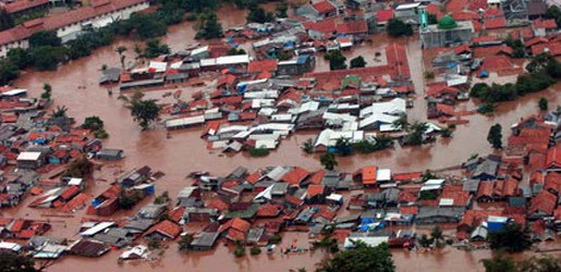
Floods
A flood is an overflow of an expanse of water that submerges land. The EU Floods directive defines a flood as a temporary covering by water of land not normally covered by water
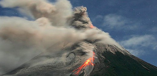
Volcanic Eruptions
Volcanoes can cause widespread destruction and consequent disaster through several ways. The effects include the volcanic eruption itself that may cause harm following the explosion of the volcano or the fall of rock.
Hail Storms Size and Terminal Velocity
12:45 AM
The size of hail stones is best determined by measuring their diameter with a ruler. In the absence of a ruler, hail stone size is often visually estimated by comparing its size to that of known objects, such as coins. Below is a table of commonly used objects for this purpose. Note that using the objects such as hen's eggs, peas, and marbles for comparing hailstone sizes is often inaccurate, due to their varied dimensions. The UK organisation, TORRO, also scales for both hailstones and hailstorms. When observed at an airport, METAR code is used within a surface weather observation which relates to the size of the hail stone. Within METAR code, GR is used to indicate larger hail, of a diameter of at least 0.25 inches (6.4 mm). GR is derived from the French word grêle. Smaller-sized hail, as well as snow pellets, use the coding of GS, which is short for the French word grésil.
![]() Terminal velocity of hail, or the speed at which hail is falling when it strikes the ground, varies by the diameter of the hail stones. A hail stone of 1 centimetre (0.39 in) in diameter falls at a rate of 9 metres per second (20 mph), while stones the size of 8 centimetres (3.1 in) in diameter fall at a rate of 48 metres per second (110 mph). Hail stone velocity is dependent on the size of the stone, friction with air it is falling through, the motion of wind it is falling through, collisions with raindrops or other hail stones, and melting as the stones fall through a warmer atmosphere.
Terminal velocity of hail, or the speed at which hail is falling when it strikes the ground, varies by the diameter of the hail stones. A hail stone of 1 centimetre (0.39 in) in diameter falls at a rate of 9 metres per second (20 mph), while stones the size of 8 centimetres (3.1 in) in diameter fall at a rate of 48 metres per second (110 mph). Hail stone velocity is dependent on the size of the stone, friction with air it is falling through, the motion of wind it is falling through, collisions with raindrops or other hail stones, and melting as the stones fall through a warmer atmosphere.
| United States | Canada | |
|---|---|---|
| Dime | 0.705 inches (17.9 mm) | 18.03 millimetres (0.710 in) |
| Cent (or "Penny") | 0.75 inches (19 mm) | 19.05 millimetres (0.750 in) |
| Five cents (Nickel) | 0.88 inches (22 mm) | 21.2 millimetres (0.83 in) |
| Twenty-five cents (Quarter dollar) | 1.00 inch (25 mm) | 23.88 millimetres (0.940 in) |
| Dollar (Loonie) | 1.043 inches (26.5 mm) | 26.5 millimetres (1.04 in) |
| 50 Cents/Half Dollar | 1.25 inches (32 mm) | 27.13 millimetres (1.068 in) |
| Two Dollars (Toonie) | 28 millimetres (1.1 in) |
| Object | Diameter |
|---|---|
| Pea | 0.25 inches (6.4 mm) |
| Marble (small) | 0.50 inches (13 mm) |
| Mothball | 0.50 inches (13 mm) |
| Grape (small) | 0.62 inches (16 mm) |
| Olive (large) | 0.75 inches (19 mm) |
| Shooter Marble | 0.75 inches (19 mm) |
| Walnut/Ping-pong ball | 1.50 inches (38 mm) |
| Ping-pong ball | 1.60 inches (41 mm) |
| Squash ball | 1.65 inches (42 mm) |
| Golf ball | 1.75 inches (44 mm) |
| Hen egg | 2.00 inches (51 mm) |
| Billiards (Pool) Ball | 2.25 inches (57 mm) |
| Orange (Valencia/sweet) | 2.38 inches (60 mm) |
| Tennis ball | 2.50 inches (64 mm) |
| Baseball | 2.75 inches (70 mm) |
| Cricket ball | 2.80 inches (71 mm) |
| Teacup | 3.00 inches (76 mm) |
| Grapefruit | 4.00 inches (102 mm) |
| Softball | 4.50 inches (114 mm) |
| Melon (small) | 4.75 inches (121 mm) |
| Computer CD | 5.00 inches (127 mm) |
| Cantaloupe | 6.50 inches (165 mm) |
| 45 RPM Phonograph Record | 7.00 inches (178 mm) |
| Volleyball | 8.00 inches (203 mm) |
| Bowling Ball | 8.25 inches (210 mm) |
Hail Storms Climatology
12:44 AM
Hail occurs most frequently within continental interiors at mid-latitudes and is less common in the tropics, despite a much higher frequency of thunderstorms than in the midlatitudes. Hail is also much more common along mountain ranges because mountains force horizontal winds upwards (known as orographic lifting), thereby intensifying the updrafts within thunderstorms and making hail more likely. One of the more common regions for large hail is across mountainous northern India, which reported one of the highest hail-related death tolls on record in 1888. China also experiences significant hailstorms. Central Europe experiences also a lot of hailstorms. Popular regions for hailstorms are southern and western Germany, northern and eastern France and southern and eastern BeNeLux. In south-eastern Europe, Croatia and Serbia experience frequent occurrences of hail.
In North America, hail is most common in the area where Colorado, Nebraska, and Wyoming meet, known as "Hail Alley." Hail in this region occurs between the months of March and October during the afternoon and evening hours, with the bulk of the occurrences from May through September. Cheyenne, Wyoming is North America's most hail-prone city with an average of nine to ten hailstorms per season.Hail Storms Short-Term Detection
12:42 AM
Weather radar is a very useful tool to detect the presence of hail producing thunderstorms. However, radar data has to be complemented by a knowledge of current atmospheric conditions which can allow one to determine if the current atmosphere is conducive to hail development.
Modern radar scans many angles around the site. Reflectivity values at multiple angles above ground level in a storm are proportional to the precipitation rate at those levels. Summing reflectivities in the Vertically Integrated Liquid or VIL, gives the liquid water content in the cloud. Research shows that hail development in the upper levels of the storm is related to the evolution of VIL. VIL divided by the vertical extent of the storm, called VIL density, has a relationship with hail size, although this varies with atmospheric conditions and therefore is not highly accurate. Traditionally, hail size and probability can be estimated from radar data by computer using algorithms based on this research. Some algorithms include the height of the freezing level to estimate the melting of the hailstone and what would be left on the ground.
Certain patterns of reflectivity are important clues for the meteorologist as well. The three body scatter spike is an example. This is the result of energy from the radar hitting hail and being deflected to the ground, where they deflect back to the hail and then to the radar. The energy took more time to go from the hail to the ground and back, as opposed to the energy that went direct from the hail to the radar, and the echo is further away from the radar than the actual location of the hail on the same radial path, forming a cone of weaker reflectivities.
More recently, the polarization properties of weather radar returns have been analyzed to differentiate between hail and heavy rain. The use of differential reflectivity (Zdr), in combination with horizontal reflectivity (Zh) has led to a variety of hail classification algorithms. Visible satellite imagery is beginning to be used to detect hail, but false alarm rates remain high using this method.Hail Storms Formation
12:39 AM

Hail forms in strong thunderstorm clouds, particularly those with intense updrafts, high liquid water content, great vertical extent, large water droplets, and where a good portion of the cloud layer is below freezing 0 °C (32 °F). These type of strong updrafts can also indicate the presence of a tornado. The growth rate is maximized where air is near a temperature of −13 °C (9 °F).
Layer nature of the hailstones
Like other precipitation in cumulonimbus clouds hail begins as water droplets. As the droplets rise and the temperature goes below freezing, they become supercooled water and will freeze on contact with condensation nuclei. A cross-section through a large hailstone shows an onion-like structure. This means the hailstone is made of thick and translucent layers, alternating with layers that are thin, white and opaque. Former theory suggested that hailstones were subjected to multiple descents and ascents, falling into a zone of humidity and refreezing as they were uplifted. This up and down motion was thought to be responsible for the successive layers of the hailstone. New research (based on theory and field study) has shown this is not necessarily true.
The storm's updraft, with upwardly directed wind speeds as high as 110 miles per hour (180 km/h), blow the forming hailstones up the cloud. As the hailstone ascends it passes into areas of the cloud where the concentration of humidity and supercooled water droplets varies. The hailstone’s growth rate changes depending on the variation in humidity and supercooled water droplets that it encounters. The accretion rate of these water droplets is another factor in the hailstone’s growth. When the hailstone moves into an area with a high concentration of water droplets, it captures the latter and acquires a translucent layer. Should the hailstone move into an area where mostly water vapour is available, it acquires a layer of opaque white ice.
Furthermore, the hailstone’s speed depends on its position in the cloud’s updraft and its mass. This determines the varying thicknesses of the layers of the hailstone. The accretion rate of supercooled water droplets onto the hailstone depends on the relative velocities between these water droplets and the hailstone itself. This means that generally the larger hailstones will form some distance from the stronger updraft where they can pass more time growing. As the hailstone grows it releases latent heat, which keeps its exterior in a liquid phase. Undergoing 'wet growth', the outer layer is sticky, or more adhesive, so a single hailstone may grow by collision with other smaller hailstones, forming a larger entity with an irregular shape.
The hailstone will keep rising in the thunderstorm until its mass can no longer be supported by the updraft. This may take at least 30 minutes based on the force of the updrafts in the hail-producing thunderstorm, whose top is usually greater than 10 km high. It then falls toward the ground while continuing to grow, based on the same processes, until it leaves the cloud. It will later begin to melt as it passes into air above freezing temperature.
Thus, a unique trajectory in the thunderstorm is sufficient to explain the layer-like structure of the hailstone. The only case in which we can discuss mutiple trajectories is in a multicellular thunderstorm where the hailstone may be ejected from the top of the "mother" cell and captured in the updraft of a more intense "daughter cell". This however is an exceptional case.
Factors favoring hail
Hail is most common within continental interiors of the mid-latitudes, as hail formation is considerably more likely when the freezing level is below the altitude of 11,000 feet (3,400 m). Movement of dry air into strong thunderstorms over continents can increase the frequency of hail by promoting evaporational cooling which lowers the freezing level of thunderstorm clouds giving hail a larger volume to grow in. Accordingly, hail is actually less common in the tropics despite a much higher frequency of thunderstorms than in the mid-latitudes because the atmosphere over the tropics tends to be warmer over a much greater depth. Hail in the tropics occurs mainly at higher elevations.
Hail growth becomes vanishingly small when air temperatures fall below −30 °C (−22 °F) as supercooled water droplets become rare at these temperatures. Around thunderstorms, hail is most likely within the cloud at elevations above 20,000 feet (6,100 m). Between 10,000 feet (3,000 m) and 20,000 feet (6,100 m), 60 percent of hail is still within the thunderstorm, though 40 percent now lies within the clear air under the anvil. Below 10,000 feet (3,000 m), hail is equally distributed in and around a thunderstorm to a distance of 2 nautical miles (3.7 km).What is Hail Storms
12:35 AM

Hail is a form of solid precipitation which consists of balls or irregular lumps of ice, that are individually called hail stones. Hail stones on Earth consist mostly of water ice and measure between 5 millimetres (0.20 in) and 200 millimetres (7.9 in) in diameter, with the larger stones coming from severe thunderstorms. The METAR reporting code for hail 5 millimetres (0.20 in) or greater in diameter is GR, while smaller hailstones and graupel are coded GS. Hail is possible within most thunderstorms as it is produced by cumulonimbi (thunderclouds), and within 2 nautical miles (3.7 km) of the parent storm. Hail formation requires environments of strong, upward motion of air with the parent thunderstorm (similar to tornadoes) and lowered heights of the freezing level. Hail is most frequently formed in the interior of continents within the mid-latitudes of Earth, with hail generally confined to higher elevations within the tropics.
There are methods available to detect hail-producing thunderstorms using weather satellites and weather radar imagery. Hail stones generally fall at higher speeds as they grow in size, though complicating factors such as melting, friction with air, wind, and interaction with rain and other hail stones can slow their descent through Earth's atmosphere. Severe weather warnings are issued for hail when the stones reach a damaging size, as it can cause serious damage to man-made structures and, most commonly, farmers' crops.
Definition
Any thunderstorm which produces hail that reaches the ground is known as a hailstorm. Hail has a diameter of 5 millimetres (0.20 in) or more. Hail stones can grow to 15 centimetres (6 in) and weigh more than 0.5 kilograms (1.1 lb).
Unlike ice pellets, hail stones are layered and can be irregular and clumped together. Hail is composed of transparent ice or alternating layers of transparent and translucent ice at least 1 millimetre (0.039 in) thick, which are deposited upon the hail stone as it cycles through the cloud, suspended aloft by air with strong upward motion until its weight overcomes the updraft and falls to the ground. Although the diameter of hail is varied, in the United States, the average observation of damaging hail is between 2.5 cm (1 in) and golf ball-sized (1.75 in).
Stones larger than 2 cm (0.75 in) are usually considered large enough to cause damages. The Meteorological Service of Canada will issue severe thunderstorm warnings when hail that size or above is expected. The US National Weather Service has a 2.5 cm (1 in) or greater in diameter threshold, effective January 2010, an increase over the previous threshold of ¾ inch hail. Other countries will have different thresholds according local sensitivity to hail, for instance grape growing areas could be adversely impacted by smaller hailstones.