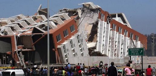
Earthquake
An earthquake (also known as a quake, tremor or temblor) is the result of a sudden release of energy in the Earth's crust that creates seismic waves.
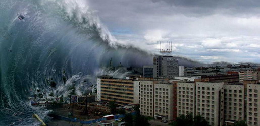
Tsunami
A tsunami also called a tsunami wave train, and at one time incorrectly referred to as a tidal wave, is a series of water waves caused by the displacement of a large volume of a body of water, usually an ocean, though it can occur in large lakes.
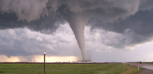
Tornado
A tornado (often referred to as a twister or, erroneously, a cyclone) is a violent, dangerous, rotating column of air that is in contact with both the surface of the earth and a cumulonimbus cloud or, in rare cases, the base of a cumulus cloud.
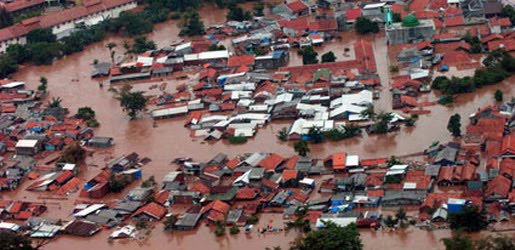
Floods
A flood is an overflow of an expanse of water that submerges land. The EU Floods directive defines a flood as a temporary covering by water of land not normally covered by water
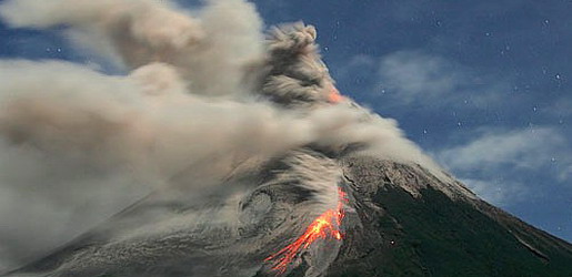
Volcanic Eruptions
Volcanoes can cause widespread destruction and consequent disaster through several ways. The effects include the volcanic eruption itself that may cause harm following the explosion of the volcano or the fall of rock.
Effects of Tropical Cyclones
8:34 AM
Tropical cyclones out at sea cause large waves, heavy rain, and high winds, disrupting international shipping and, at times, causing shipwrecks. Tropical cyclones stir up water, leaving a cool wake behind them, which causes the region to be less favorable for subsequent tropical cyclones. On land, strong winds can damage or destroy vehicles, buildings, bridges, and other outside objects, turning loose debris into deadly flying projectiles. The storm surge, or the increase in sea level due to the cyclone, is typically the worst effect from landfalling tropical cyclones, historically resulting in 90% of tropical cyclone deaths. The broad rotation of a landfalling tropical cyclone, and vertical wind shear at its periphery, spawns tornadoes. Tornadoes can also be spawned as a result of eyewall mesovortices, which persist until landfall.
Over the past two centuries, tropical cyclones have been responsible for the deaths of about 1.9 million people worldwide. Large areas of standing water caused by flooding lead to infection, as well as contributing to mosquito-borne illnesses. Crowded evacuees in shelters increase the risk of disease propagation. Tropical cyclones significantly interrupt infrastructure, leading to power outages, bridge destruction, and the hampering of reconstruction efforts.
Although cyclones take an enormous toll in lives and personal property, they may be important factors in the precipitation regimes of places they impact, as they may bring much-needed precipitation to otherwise dry regions. Tropical cyclones also help maintain the global heat balance by moving warm, moist tropical air to the middle latitudes and polar regions. The storm surge and winds of hurricanes may be destructive to human-made structures, but they also stir up the waters of coastal estuaries, which are typically important fish breeding locales. Tropical cyclone destruction spurs redevelopment, greatly increasing local property values.The main effects of tropical cyclones include heavy rain, strong wind, large storm surges at landfall, and tornadoes. The destruction from a tropical cyclone depends mainly on its intensity, its size, and its location. Tropical cyclones act to remove forest canopy as well as change the landscape near coastal areas, by moving and reshaping sand dunes and causing extensive erosion along the coast. Even well inland, heavy rainfall can lead to mudslides and landslides in mountainous areas. Their effects can be sensed over time by studying the concentration of the Oxygen-18 isotope within caves within the vicinity of cyclones' paths.
After the cyclone has passed, devastation often continues. Standing water can cause the spread of disease, and transportation or communications infrastructure may have been destroyed, hampering clean-up and rescue efforts. Nearly two million people have died globally due to tropical cyclones. Despite their devastating effects, tropical cyclones are also beneficial, by potentially bringing rain to dry areas and moving heat from the tropics poleward. Out at sea, ships take advantage of their known characteristics by navigating through their weaker, western half.
Tropical Cyclone Dissipation
8:31 AM
Factors
A tropical cyclone can cease to have tropical characteristics in several different ways. One such way is if it moves over land, thus depriving it of the warm water it needs to power itself, quickly losing strength. Most strong storms lose their strength very rapidly after landfall and become disorganized areas of low pressure within a day or two, or evolve into extratropical cyclones. There is a chance a tropical cyclone could regenerate if it managed to get back over open warm water, such as with Hurricane Ivan. If it remains over mountains for even a short time, weakening will accelerate. Many storm fatalities occur in mountainous terrain, as the dying storm unleashes torrential rainfall, leading to deadly floods and mudslides, similar to those that happened with Hurricane Mitch in 1998. Additionally, dissipation can occur if a storm remains in the same area of ocean for too long, mixing the upper 60 metres (200 ft) of water, dropping sea surface temperatures more than 5 °C (9 °F). Without warm surface water, the storm cannot survive.
A tropical cyclone can dissipate when it moves over waters significantly below 26.5 °C (79.7 °F). This will cause the storm to lose its tropical characteristics (i.e. thunderstorms near the center and warm core) and become a remnant low pressure area, which can persist for several days. This is the main dissipation mechanism in the Northeast Pacific ocean. Weakening or dissipation can occur if it experiences vertical wind shear, causing the convection and heat engine to move away from the center; this normally ceases development of a tropical cyclone. Additionally, its interaction with the main belt of the Westerlies, by means of merging with a nearby frontal zone, can cause tropical cyclones to evolve into extratropical cyclones. This transition can take 1–3 days. Even after a tropical cyclone is said to be extratropical or dissipated, it can still have tropical storm force (or occasionally hurricane/typhoon force) winds and drop several inches of rainfall. In the Pacific ocean and Atlantic ocean, such tropical-derived cyclones of higher latitudes can be violent and may occasionally remain at hurricane or typhoon-force wind speeds when they reach the west coast of North America. These phenomena can also affect Europe, where they are known as European windstorms; Hurricane Iris's extratropical remnants are an example of such a windstorm from 1995. Additionally, a cyclone can merge with another area of low pressure, becoming a larger area of low pressure. This can strengthen the resultant system, although it may no longer be a tropical cyclone. Studies in the 2000s have given rise to the hypothesis that large amounts of dust reduce the strength of tropical cyclones.
Artificial dissipation
In the 1960s and 1970s, the United States government attempted to weaken hurricanes through Project Stormfury by seeding selected storms with silver iodide. It was thought that the seeding would cause supercooled water in the outer rainbands to freeze, causing the inner eyewall to collapse and thus reducing the winds. The winds of Hurricane Debbie—a hurricane seeded in Project Stormfury—dropped as much as 31%, but Debbie regained its strength after each of two seeding forays. In an earlier episode in 1947, disaster struck when a hurricane east of Jacksonville, Florida promptly changed its course after being seeded, and smashed into Savannah, Georgia. Because there was so much uncertainty about the behavior of these storms, the federal government would not approve seeding operations unless the hurricane had a less than 10% chance of making landfall within 48 hours, greatly reducing the number of possible test storms. The project was dropped after it was discovered that eyewall replacement cycles occur naturally in strong hurricanes, casting doubt on the result of the earlier attempts. Today, it is known that silver iodide seeding is not likely to have an effect because the amount of supercooled water in the rainbands of a tropical cyclone is too low.
Other approaches have been suggested over time, including cooling the water under a tropical cyclone by towing icebergs into the tropical oceans. Other ideas range from covering the ocean in a substance that inhibits evaporation, dropping large quantities of ice into the eye at very early stages of development (so that the latent heat is absorbed by the ice, instead of being converted to kinetic energy that would feed the positive feedback loop), or blasting the cyclone apart with nuclear weapons.[18] Project Cirrus even involved throwing dry ice on a cyclone. These approaches all suffer from one flaw above many others: tropical cyclones are simply too large and short-lived for any of the weakening techniques to be practical.
Tropical Cyclone Movement and Track
8:29 AM
Steering winds
Although tropical cyclones are large systems generating enormous energy, their movements over the Earth's surface are controlled by large-scale winds—the streams in the Earth's atmosphere. The path of motion is referred to as a tropical cyclone's track and has been compared by Dr. Neil Frank, former director of the National Hurricane Center, to "leaves carried along by a stream".
Tropical systems, while generally located equatorward of the 20th parallel, are steered primarily westward by the east-to-west winds on the equatorward side of the subtropical ridge—a persistent high pressure area over the world's oceans. In the tropical North Atlantic and Northeast Pacific oceans, trade winds—another name for the westward-moving wind currents—steer tropical waves westward from the African coast and towards the Caribbean Sea, North America, and ultimately into the central Pacific ocean before the waves dampen out. These waves are the precursors to many tropical cyclones within this region. In the Indian Ocean and Western Pacific (both north and south of the equator), tropical cyclogenesis is strongly influenced by the seasonal movement of the Intertropical Convergence Zone and the monsoon trough, rather than by easterly waves. Tropical cyclones can also be steered by other systems, such as other low pressure systems, high pressure systems, warm fronts, and cold fronts.
Coriolis effect
The Earth's rotation imparts an acceleration known as the Coriolis effect, Coriolis acceleration, or colloquially, Coriolis force. This acceleration causes cyclonic systems to turn towards the poles in the absence of strong steering currents. The poleward portion of a tropical cyclone contains easterly winds, and the Coriolis effect pulls them slightly more poleward. The westerly winds on the equatorward portion of the cyclone pull slightly towards the equator, but, because the Coriolis effect weakens toward the equator, the net drag on the cyclone is poleward. Thus, tropical cyclones in the Northern Hemisphere usually turn north (before being blown east), and tropical cyclones in the Southern Hemisphere usually turn south (before being blown east) when no other effects counteract the Coriolis effect.
The Coriolis effect also initiates cyclonic rotation, but it is not the driving force that brings this rotation to high speeds – that force is the heat of condensation.
Interaction with the mid-latitude westerlies
When a tropical cyclone crosses the subtropical ridge axis, its general track around the high-pressure area is deflected significantly by winds moving towards the general low-pressure area to its north. When the cyclone track becomes strongly poleward with an easterly component, the cyclone has begun recurvature. A typhoon moving through the Pacific Ocean towards Asia, for example, will recurve offshore of Japan to the north, and then to the northeast, if the typhoon encounters southwesterly winds (blowing northeastward) around a low-pressure system passing over China or Siberia. Many tropical cyclones are eventually forced toward the northeast by extratropical cyclones in this manner, which move from west to east to the north of the subtropical ridge. An example of a tropical cyclone in recurvature was Typhoon Ioke in 2006, which took a similar trajectory.Landfall
Officially, landfall is when a storm's center (the center of its circulation, not its edge) crosses the coastline. Storm conditions may be experienced on the coast and inland hours before landfall; in fact, a tropical cyclone can launch its strongest winds over land, yet not make landfall; if this occurs, then it is said that the storm made a direct hit on the coast. As a result of the narrowness of this definition, the landfall area experiences half of a land-bound storm by the time the actual landfall occurs. For emergency preparedness, actions should be timed from when a certain wind speed or intensity of rainfall will reach land, not from when landfall will occur.
Multiple storm interaction
When two cyclones approach one another, their centers will begin orbiting cyclonically about a point between the two systems. The two vortices will be attracted to each other, and eventually spiral into the center point and merge. When the two vortices are of unequal size, the larger vortex will tend to dominate the interaction, and the smaller vortex will orbit around it. This phenomenon is called the Fujiwhara effect, after Sakuhei Fujiwhara.
Tropical Cyclone Formation
10:03 AM
Worldwide, tropical cyclone activity peaks in late summer, when the difference between temperatures aloft and sea surface temperatures is the greatest. However, each particular basin has its own seasonal patterns. On a worldwide scale, May is the least active month, while September is the most active while November is the only month with all the tropical cyclone basins active.
Times
In the Northern Atlantic Ocean, a distinct cyclone season occurs from June 1 to November 30, sharply peaking from late August through September. The statistical peak of the Atlantic hurricane season is 10 September. The Northeast Pacific Ocean has a broader period of activity, but in a similar time frame to the Atlantic. The Northwest Pacific sees tropical cyclones year-round, with a minimum in February and March and a peak in early September. In the North Indian basin, storms are most common from April to December, with peaks in May and November. In the Southern Hemisphere, the tropical cyclone year begins on July 1 and runs all year round and encompasses the tropical cyclone seasons which run from November 1 until the end of April with peaks in mid-February to early March.
| Season lengths and seasonal averages | |||||
|---|---|---|---|---|---|
| Basin | Season start | Season end | Tropical Storms (>34 knots) | Tropical Cyclones (>63 knots) | Category 3+ TCs (>95 knots) |
| Northwest Pacific | April | January | 26.7 | 16.9 | 8.5 |
| South Indian | November | April | 20.6 | 10.3 | 4.3 |
| Northeast Pacific | May | November | 16.3 | 9.0 | 4.1 |
| North Atlantic | June | November | 10.6 | 5.9 | 2.0 |
| Australia Southwest Pacific | November | April | 9 | 4.8 | 1.9 |
| North Indian | April | December | 5.4 | 2.2 | 0.4 |
Factors
The formation of tropical cyclones is the topic of extensive ongoing research and is still not fully understood. While six factors appear to be generally necessary, tropical cyclones may occasionally form without meeting all of the following conditions. In most situations, water temperatures of at least 26.5 °C (79.7 °F) are needed down to a depth of at least 50 m (160 ft); waters of this temperature cause the overlying atmosphere to be unstable enough to sustain convection and thunderstorms. Another factor is rapid cooling with height, which allows the release of the heat of condensation that powers a tropical cyclone. High humidity is needed, especially in the lower-to-mid troposphere; when there is a great deal of moisture in the atmosphere, conditions are more favorable for disturbances to develop. Low amounts of wind shear are needed, as high shear is disruptive to the storm's circulation. Tropical cyclones generally need to form more than 555 km (345 mi) or 5 degrees of latitude away from the equator, allowing the Coriolis effect to deflect winds blowing towards the low pressure center and creating a circulation. Lastly, a formative tropical cyclone needs a pre-existing system of disturbed weather, although without a circulation no cyclonic development will take place. Low-latitude and low-level westerly wind bursts associated with the Madden-Julian oscillation can create favorable conditions for tropical cyclogenesis by initiating tropical disturbances.
Locations
Most tropical cyclones form in a worldwide band of thunderstorm activity called by several names: the Intertropical Front (ITF), the Intertropical Convergence Zone (ITCZ), or the monsoon trough. Another important source of atmospheric instability is found in tropical waves, which cause about 85% of intense tropical cyclones in the Atlantic ocean, and become most of the tropical cyclones in the Eastern Pacific basin.
Tropical cyclones move westward when equatorward of the subtropical ridge, intensifying as they move. Most of these systems form between 10 and 30 degrees away of the equator, and 87% form no farther away than 20 degrees of latitude, north or south. Because the Coriolis effect initiates and maintains tropical cyclone rotation, tropical cyclones rarely form or move within about 5 degrees of the equator, where the Coriolis effect is weakest. However, it is possible for tropical cyclones to form within this boundary as Tropical Storm Vamei did in 2001 and Cyclone Agni in 2004.Tropical Cyclone Mechanics
10:00 AM

A tropical cyclone's primary energy source is the release of the heat of condensation from water vapor condensing, with solar heating being the initial source for evaporation. Therefore, a tropical cyclone can be visualized as a giant vertical heat engine supported by mechanics driven by physical forces such as the rotation and gravity of the Earth. In another way, tropical cyclones could be viewed as a special type of mesoscale convective complex, which continues to develop over a vast source of relative warmth and moisture. While an initial warm core system, such as an organized thunderstorm complex, is necessary for the formation of a tropical cyclone, a large flux of energy is needed to lower atmospheric pressure more than a few millibars (0.10 inch of mercury). The inflow of warmth and moisture from the underlying ocean surface is critical for tropical cyclone strengthening. A significant amount of the inflow in the cyclone is in the lowest 1 kilometre (3,300 ft) of the atmosphere.
Condensation leads to higher wind speeds, as a tiny fraction of the released energy is converted into mechanical energy; the faster winds and lower pressure associated with them in turn cause increased surface evaporation and thus even more condensation. Much of the released energy drives updrafts that increase the height of the storm clouds, speeding up condensation. This positive feedback loop, called the Wind-induced surface heat exchange, continues for as long as conditions are favorable for tropical cyclone development. Factors such as a continued lack of equilibrium in air mass distribution would also give supporting energy to the cyclone. The rotation of the Earth causes the system to spin, an effect known as the Coriolis effect, giving it a cyclonic characteristic and affecting the trajectory of the storm.
What primarily distinguishes tropical cyclones from other meteorological phenomena is deep convection as a driving force. Because convection is strongest in a tropical climate, it defines the initial domain of the tropical cyclone. By contrast, mid-latitude cyclones draw their energy mostly from pre-existing horizontal temperature gradients in the atmosphere. To continue to drive its heat engine, a tropical cyclone must remain over warm water, which provides the needed atmospheric moisture to keep the positive feedback loop running. When a tropical cyclone passes over land, it is cut off from its heat source and its strength diminishes rapidly.
The passage of a tropical cyclone over the ocean causes the upper layers of the ocean to cool substantially, which can influence subsequent cyclone development. This cooling is primarily caused by wind-driven mixing of cold water from deeper in the ocean and the warm surface waters. This effect results in a negative feedback process which can inhibit further development or lead to weakening. Additional cooling may come in the form of cold water from falling raindrops (this is because the atmosphere is cooler at higher altitudes). Cloud cover may also play a role in cooling the ocean, by shielding the ocean surface from direct sunlight before and slightly after the storm passage. All these effects can combine to produce a dramatic drop in sea surface temperature over a large area in just a few days.
Scientists estimate that a tropical cyclone releases heat energy at the rate of 50 to 200 exajoules (1018 J) per day, equivalent to about 1 PW (1015 watt). This rate of energy release is equivalent to 70 times the world energy consumption of humans and 200 times the worldwide electrical generating capacity, or to exploding a 10-megaton nuclear bomb every 20 minutes.[19][26]
In the lower troposphere, the most obvious motion of clouds is toward the center. However tropical cyclones also develop an upper-level (high-altitude) outward flow of clouds. These originate from air that has released its moisture and is expelled at high altitude through the "chimney" of the storm engine. This outflow produces high, cirrus clouds that spiral away from the center. The clouds thin as they move outwards from the center of the system and are evaporated. They may be thin enough for the sun to be visible through them. These high cirrus clouds may be the first signs of an approaching tropical cyclone. As air parcels are lifted within the eye of the storm the vorticity is reduced, causing the outflow from a tropical cyclone to have anti-cyclonic motion.
Physical Structure of a Tropical Cyclone
9:57 AM

All tropical cyclones are areas of low atmospheric pressure in the Earth's atmosphere. The pressures recorded at the centers of tropical cyclones are among the lowest that occur on Earth's surface at sea level. Tropical cyclones are characterized and driven by the release of large amounts of latent heat of condensation, which occurs when moist air is carried upwards and its water vapor condenses. This heat is distributed vertically around the center of the storm. Thus, at any given altitude (except close to the surface, where water temperature dictates air temperature) the environment inside the cyclone is warmer than its outer surroundings.
Tropical Cyclone Eye and center
A strong tropical cyclone will harbor an area of sinking air at the center of circulation. If this area is strong enough, it can develop into a large "eye". Weather in the eye is normally calm and free of clouds, although the sea may be extremely violent. The eye is normally circular in shape, and may range in size from 3 kilometres (1.9 mi) to 370 kilometres (230 mi) in diameter. Intense, mature tropical cyclones can sometimes exhibit an outward curving of the eyewall's top, making it resemble a football stadium; this phenomenon is thus sometimes referred to as the stadium effect.
There are other features that either surround the eye, or cover it. The central dense overcast is the concentrated area of strong thunderstorm activity near the center of a tropical cyclone; in weaker tropical cyclones, the CDO may cover the center completely. The eyewall is a circle of strong thunderstorms that surrounds the eye; here is where the greatest wind speeds are found, where clouds reach the highest, and precipitation is the heaviest. The heaviest wind damage occurs where a tropical cyclone's eyewall passes over land. Eyewall replacement cycles occur naturally in intense tropical cyclones. When cyclones reach peak intensity they usually have an eyewall and radius of maximum winds that contract to a very small size, around 10 kilometres (6.2 mi) to 25 kilometres (16 mi). Outer rainbands can organize into an outer ring of thunderstorms that slowly moves inward and robs the inner eyewall of its needed moisture and angular momentum. When the inner eyewall weakens, the tropical cyclone weakens (in other words, the maximum sustained winds weaken and the central pressure rises.) The outer eyewall replaces the inner one completely at the end of the cycle. The storm can be of the same intensity as it was previously or even stronger after the eyewall replacement cycle finishes. The storm may strengthen again as it builds a new outer ring for the next eyewall replacement.
| Size descriptions of tropical cyclones | |
|---|---|
| ROCI | Type |
| Less than 2 degrees latitude | Very small/midget |
| 2 to 3 degrees of latitude | Small |
| 3 to 6 degrees of latitude | Medium/Average |
| 6 to 8 degrees of latitude | Large anti-dwarf |
| Over 8 degrees of latitude | Very large |
Tropical Cyclone Size
One measure of the size of a tropical cyclone is determined by measuring the distance from its center of circulation to its outermost closed isobar, also known as its ROCI. If the radius is less than two degrees of latitude or 222 kilometres (138 mi), then the cyclone is "very small" or a "midget". A radius between 3 and 6 latitude degrees or 333 kilometres (207 mi) to 670 kilometres (420 mi) are considered "average-sized". "Very large" tropical cyclones have a radius of greater than 8 degrees or 888 kilometres (552 mi). Use of this measure has objectively determined that tropical cyclones in the northwest Pacific Ocean are the largest on earth on average, with Atlantic tropical cyclones roughly half their size. Other methods of determining a tropical cyclone's size include measuring the radius of gale force winds and measuring the radius at which its relative vorticity field decreases to 1×10⁻⁵ s−1 from its center.Tropical Cyclone
9:31 AM

A tropical cyclone is a storm system characterized by a large low-pressure center and numerous thunderstorms that produce strong winds and heavy rain. Tropical cyclones strengthen when water evaporated from the ocean is released as the saturated air rises, resulting in condensation of water vapor contained in the moist air. They are fueled by a different heat mechanism than other cyclonic windstorms such as nor'easters, European windstorms, and polar lows. The characteristic that separates tropical cyclones from other cyclonic systems is that at any height in the atmosphere, the center of a tropical cyclone will be warmer than its surrounds; a phenomenon called "warm core" storm systems.
The term "tropical" refers to both the geographic origin of these systems, which form almost exclusively in tropical regions of the globe, and their formation in maritime tropical air masses. The term "cyclone" refers to such storms' cyclonic nature, with counterclockwise rotation in the Northern Hemisphere and clockwise rotation in the Southern Hemisphere. The opposite direction of spin is a result of the Coriolis force. Depending on its location and strength, a tropical cyclone is referred to by names such as hurricane, typhoon, tropical storm, cyclonic storm, tropical depression, and simply cyclone.
While tropical cyclones can produce extremely powerful winds and torrential rain, they are also able to produce high waves and damaging storm surge as well as spawning tornadoes. They develop over large bodies of warm water, and lose their strength if they move over land due to increased surface friction and loss of the warm ocean as an energy source. This is why coastal regions can receive significant damage from a tropical cyclone, while inland regions are relatively safe from receiving strong winds. Heavy rains, however, can produce significant flooding inland, and storm surges can produce extensive coastal flooding up to 40 kilometres (25 mi) from the coastline. Although their effects on human populations can be devastating, tropical cyclones can also relieve drought conditions. They also carry heat and energy away from the tropics and transport it toward temperate latitudes, which makes them an important part of the global atmospheric circulation mechanism. As a result, tropical cyclones help to maintain equilibrium in the Earth's troposphere, and to maintain a relatively stable and warm temperature worldwide.
Many tropical cyclones develop when the atmospheric conditions around a weak disturbance in the atmosphere are favorable. The background environment is modulated by climatological cycles and patterns such as the Madden-Julian oscillation, El Niño-Southern Oscillation, and the Atlantic multidecadal oscillation. Others form when other types of cyclones acquire tropical characteristics. Tropical systems are then moved by steering winds in the troposphere; if the conditions remain favorable, the tropical disturbance intensifies, and can even develop an eye. On the other end of the spectrum, if the conditions around the system deteriorate or the tropical cyclone makes landfall, the system weakens and eventually dissipates. It is not possible to artificially induce the dissipation of these systems with current technology.
Notable Ice Storms
12:19 PM
An ice storm which struck northern Idaho in January 1961 set a record for thickest recorded ice accumulation from a single storm in the United States, at 8 inches.
In 1994, a severe ice storm caused over $1 billion in damage in the Southern United States in February 1994, primarily in Mississippi, Tennessee, and Alabama.
The North American ice storm of 1998 occurred during January 5–9, 1998. It was one of the most damaging and costly ice storms in North American history. The storm caused massive power failures in several large cities on the East Coast of the United States. The most affected area was extreme eastern Ontario and southwestern Quebec in Canada, where over 3 million people were without power for up to a month and a half. Whole trees snapped and electrical pylons were completely flattened under the weight of the accumulated ice.
The Northeastern United States was impacted by a major ice storm on December 11–12, 2008, which left about 1.25 million homes and businesses without power. Areas impacted with 3/4" to 1" of ice accumulation included eastern New York in the Albany area, central and western Massachusetts, southern New Hampshire, coastal and south-central Maine, Pennsylvania in the Pocono Mountains region, northwestern Connecticut, and southern Vermont. Southern New Hampshire and northernmost Massachusetts got hit the worst with the storm with ice accumulations ranging from 1.5 in to 3 in of ice. This left residents unable to get supplies, go to work etc. due to blocked roads from trees that fell on the roads. Any trees that fell quickly took down power poles. It took utility crews from 4 to as much as 16 days to get a look at the damage and start to restore power to nearly 1.3 million people. In all there were 675,000 residents in New Hampshire without power and around 500,000 in northern Massachusetts
In late January, 2009, ice storms covered several U.S. states, including Arkansas and Kentucky. Most areas affected saw over 2" of ice accumulation, and between 1"–5" of snow on top of the ice. This ice storm left well over 2 million people without power at its peak and killed 55 people, 24 in Kentucky. Rural Water Associations in Arkansas and Kentucky activated emergency response plans to deal with power loss to small water utilities across their states. Neighboring state Rural Water Associations, including experienced emergency responders from Louisiana and Florida, loaned equipment and manpower to assist the hardest-hit areas.
During the unusually severe winter of 2009–2010 in the United Kingdom, heavy snow had fallen over much of the country in late December and early January. By the second week of January, many of the roads and pavements had been cleared by local councils due to the use of rock salt gritting. However, during the early hours of 12 January, a wet front moved across the country, causing freezing rain and heavy ice glaze, particularly in the South and West Yorkshire areas of Northern England (crucially, this rainfall had stopped before first light). When the local population prepared to set out for work and school, they saw from their windows what appeared to be clear roads and pavements but were in fact treacherous sheets of black ice. Cars and buses almost immediately encounted extreme difficulty, and emergency services were called to dozens of accidents. Pedestrians in the village of Holmfirth found the only safe way to proceed was to crawl on all fours. Accident and emergency units at hospitals in the Sheffield, Rotherham, and Barnsley areas found themselves inundated by people with broken bones, fractures, and sprains, and many schools were closed as it was judged unsafe for pupils to attempt to make their way there.
On December 25, 2010, freezing rain fell on Moscow and vicinity. The glaze ice accumulation caused a number of accidents and power outages, of which the most serious was damage caused to two power lines feeding Domodedovo Airport, causing a complete blackout of the airport and express railway that connected it to the city. As a result, the airport was shut down and hundreds of passengers were stranded inside, with taxi drivers charging up to 10,000 rubles (USD 330) for a one-hour drive to the city. Other city airports, Sheremetyevo and Vnukovo, where air traffic was re-routed and amid heavy snowfall that followed ice rain, collapsed a day later, causing a full air transport collapse.
Ice Storm Effect
12:18 PM
The freezing rain from an ice storm covers everything with heavy, smooth glaze ice. Ice-covered roads become slippery and hazardous, as the ice causes vehicles to skid out of control, which can cause devastating car crashes as well as pile-ups. Pedestrians are severely affected as sidewalks become slippery, causing people to slip and fall, and outside stairs can become an extreme injury hazard.
In addition to hazardous driving or walking conditions, branches or even whole trees may break from the weight of ice. Falling branches can block roads, tear down power and telephone lines, and cause other damage. Even without falling trees and tree branches, the weight of the ice itself can easily snap power lines and also break and bring down power/utility poles; even steel frame electricity pylons have been sent crashing to the ground by the weight of the ice. This can leave people without power for anywhere from several days to a month. According to most meteorologists, just one quarter of an inch of ice accumulation can add about 500 pounds of weight per line span. Damage from ice storms is highly capable of shutting down entire metropolitan areas.
Additionally, the loss of power during ice storms has indirectly caused numerous illnesses and deaths due to unintentional carbon monoxide (CO) poisoning. At lower levels, CO poisoning causes symptoms such as nausea, dizziness, fatigue, and headache, but high levels can cause unconsciousness, heart failure, and death. The relatively high incidence of CO poisoning during ice storms occurs due to the use of alternative methods of heating and cooking during prolonged power outages, common during severe ice storms. Gas generators, charcoal and propane barbecues, and kerosene heaters contribute to CO poisoning when they operate in confined locations. CO is produced when appliances burn fuel without enough oxygen present, such as basements and other indoor locations.
Loss of electricity during ice storms can also easily lead to hypothermia and even death from hypothermia. It can also lead to ruptured pipes due to water freezing inside the pipes.
| Sensitivity to sap coloration | Resistance to ice damage to crown | ||
|---|---|---|---|
| Low or average | Average or strong | Strong | |
| Sensitive |
|
|
|
| Insensitive |
|
|
|
Ice Storm Formation
12:16 PM

Ice storms occur when a layer of warm air is between two layers of cold air. Frozen precipitation melts while falling into the warm air layer, and then proceeds to refreeze in the cold layer above the ground. If the precipitate is partially melted, it will land on the ground as sleet. However, if the warm layer completely melts the precipitate, becoming rain, the liquid droplets will continue to fall, and pass through a thin layer of cold air just above the surface. This thin layer of air then cools the rain to a temperature below freezing (0 °C). However, the drops themselves do not freeze, a phenomenon called supercooling (or forming "supercooled drops"). When the supercooled drops strike ground below 0 °C or anything else below 0 °C (power lines, tree branches, aircraft), they instantly freeze, forming a thin film of ice, hence freezing rain.
While meteorologists can predict when and where an ice storm will occur, some storms still occur with little or no warning. Most ice storms are thought to form primarily in the north-eastern US, but damaging storms have occurred farther south. An ice storm in February 1994 resulted in tremendous ice accumulation as far south as Mississippi, and caused reported damage in nine states. More timber was damaged than that caused by Hurricane Camille. An ice storm in eastern Washington in November 1996 directly followed heavy snowfall. The combined weight of the snow and 25 millimetres (0.98 in) to 37 millimetres (1.5 in) of ice caused considerable widespread damage. This was considered to be the most severe ice storm in the Spokane area since 1940.Ice Storm
12:12 PM

Heavy showers of freezing rain are one of the most dangerous types of winter storm. They typically occur when a layer of warm air hovers over a region, but the ambient temperature is near 0 °C (32 °F), and the ground temperature is sub-freezing. A storm in which only roads freeze is called a freezing rain storm; one resulting in widespread icing of plants and infrastructure is called an ice storm.
While a 10 cm (4 in) snowstorm is somewhat manageable by the standards of the northern United States and Canada, a comparable 1 cm (0.4 in) ice storm will paralyze a region: driving becomes extremely hazardous, telephone and power lines are damaged, and crops may be ruined. Because they do not require extreme cold, ice storms often occur in warm temperature climates (such as the southern United States) and cooler ones. Ice storms in Florida will often destroy entire orange crops.
Notable ice storms include an El Niño-related North American ice storm of 1998 that affected much of eastern Canada, including Montreal and Ottawa, as well as upstate New York and part of New England. Three million people lost power, some for as long as six weeks. One-third of the trees in Montreal's Mount Royal park were damaged, as well as a large proportion of the sugar-producing maple trees. The amount of economic damage caused by the storm has been estimated at $3 billion Canadian.
The Ice Storm of December 2002 in North Carolina resulted in massive power loss throughout much of the state, and property damage due to falling trees. Except in the mountainous western part of the state, heavy snow and icy conditions are rare in North Carolina.
The Ice Storm of December 2005 was another severe winter storm producing extensive ice damage across a large portion of the Southern United States on December 14 to 16. It led to power outages and at least 7 deaths.
In January 2005 Kansas had been declared a major disaster zone by President George W. Bush after an ice storm caused nearly $39 million in damages to 32 counties. Federal funds were provided to the counties during January 4–6, 2005 to aid the recovery process.
The January 2009 Central Plains and Midwest ice storm was a crippling and historic ice storm. Most places struck by the storm, saw 2 inches or more of ice accumulation, and a few of inches of snow on top it. This brought down power lines, causing some people to go without power for a few days, to a few weeks. In some cases, some didn't see power for a month or more. At the height of the storm, more than 2 million people were without power.
Snowstorms
12:10 PM

Snowstorms are storms where large amounts of snow fall. Snow is less dense than liquid water, by a factor of approximately 10 at temperatures slightly below freezing, and even more at much colder temperatures. Therefore, an amount of water that would produce 0.8 in. (2 cm.) of rain could produce at least 8 in (20 cm) of snow. Two inches of snow (5 cm.) is enough to create serious disruptions to traffic and school transport (because of the difficulty to drive and maneuver the school buses on slick roads). This is particularly true in places where snowfall is uncommon but heavy accumulating snowfalls can happen (e.g., Dallas, Atlanta, Seattle, London, Dublin, Canberra, Vancouver and Las Vegas). In places where snowfall is common, such as Utica, Detroit, Denver, Ottawa, Montreal, Quebec City, Chicago, Syracuse, Buffalo, Columbus, Pittsburgh, Toronto and Minneapolis, such small snowfalls are rarely disruptive, because of effective snow and ice removal by municipalities, greater usage of snow tires and drivers more used to winter conditions. Snowfalls in excess of 6 in (15 cm) are usually universally disruptive.
A massive snowstorm with strong winds and other conditions meeting certain criteria is known as a blizzard. A large number of heavy snowstorms, some of which were blizzards, occurred in the United States during 1888 and 1947 as well as the early and mid-1990s. The snowfall of 1947 exceeded two feet with drifts and snow piles from plowing that reached twelve feet and for months, temperatures did not rise high enough to melt the snow. The 1993 "Superstorm" was manifest as a blizzard in most of the affected area.
Large snowstorms could be quite dangerous: a 6 in. (15 cm.) snowstorm will make some unplowed roads impassable, and it is possible for automobiles to get stuck in the snow. Snowstorms exceeding 12 in (30 cm) especially in southern or generally warm climates will cave the roofs of some homes and cause the loss of power. Standing dead trees can also be brought down by the weight of the snow, especially if it is wet or very dense. Even a few inches of dry snow can form drifts many feet high under windy conditions.
Dangers of Snow
Snowstorms are usually considered less dangerous than ice storms. However, the snow can bring secondary dangers. Mountain snowstorms can produce cornices and avalanches. An additional danger, following a snowy winter, is spring flooding if the snow melts suddenly due to a dramatic rise in air temperature. Deaths can occur from hypothermia, infections brought on by frostbite or car accidents due to slippery roads. Fires and carbon monoxide poisoning can occur after a storm causes a power outage. Large amounts of snow can also significantly reduce visibility in the area, a phenomenon known as a whiteout; this can be very dangerous to those who are in a densely populated area, as the whiteout can cause major accidents on the road or while flying. There is also several cases of heart attacks caused by overexertion while shoveling heavy wet snow. It is difficult to predict what form this precipitation will take, and it may alternate between rain and snow. Therefore, weather forecasters just predict a "wintry mix". Usually, this type of precipitation occurs at temperatures between -2 °C and 2 °C (27 °F and 36 °F).
Blizzard - Snowstorm - Winterstorm
12:04 PM

A blizzard is a severe snowstorm or winter storms characterized by low temperature, strong winds, and heavy snow. The difference between a blizzard and a snow storm is the strength of the wind. To be a considered a blizzard, the storm must have winds in excess of 35 miles per hour, it should reduce the visibility to 1/4 miles, and must last for a prolonged period of 3 hours or more. Ground blizzards require high winds to stir up snow that has already fallen, rather than fresh snowfall. Blizzards have a negative impact on local economics and can terminate the visibility in regions where snowfall is rare.
Blizzards can bring near-whiteout conditions, and can paralyze regions for days at a time, particularly where snowfall is unusual or rare. The 1972 Iran blizzard, which caused approximately 4000 deaths, was the deadliest in recorded history.
 List of Blizzard Events
- Ground Hog Day Blizzard of 2011
- The New York blizzard in 2010
- Third North American blizzard of 2010
- Second North American blizzard of 2010
- First North American blizzard of 2010
- February 2007 North America Winter Storm
- Saskatchewan blizzard of 2007
- Blizzard of 1999
- Great Blizzard of 1993
- Halloween Blizzard of 1991
- Chicago Blizzard of 1979
- Northeastern United States Blizzard of 1978
- Great Blizzard of 1978
- Blizzard of 1977
- Chicago Blizzard of 1967
- North American blizzard of 1947
- Armistice Day Blizzard of 1940
- Great Lakes Storm of 1913
- Schoolhouse Blizzard of 1888, North American Great Plains
- Great Blizzard of 1888, Northeastern U.S.