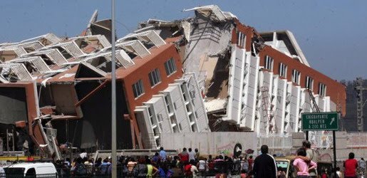
Earthquake
An earthquake (also known as a quake, tremor or temblor) is the result of a sudden release of energy in the Earth's crust that creates seismic waves.
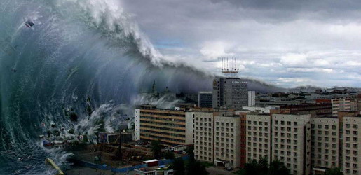
Tsunami
A tsunami also called a tsunami wave train, and at one time incorrectly referred to as a tidal wave, is a series of water waves caused by the displacement of a large volume of a body of water, usually an ocean, though it can occur in large lakes.
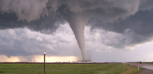
Tornado
A tornado (often referred to as a twister or, erroneously, a cyclone) is a violent, dangerous, rotating column of air that is in contact with both the surface of the earth and a cumulonimbus cloud or, in rare cases, the base of a cumulus cloud.
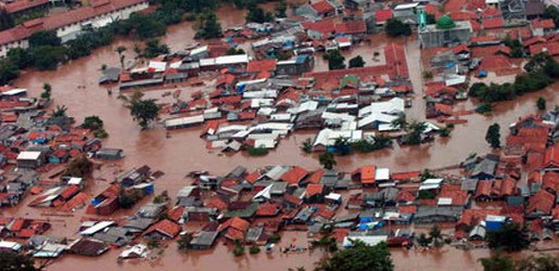
Floods
A flood is an overflow of an expanse of water that submerges land. The EU Floods directive defines a flood as a temporary covering by water of land not normally covered by water
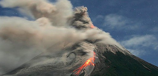
Volcanic Eruptions
Volcanoes can cause widespread destruction and consequent disaster through several ways. The effects include the volcanic eruption itself that may cause harm following the explosion of the volcano or the fall of rock.
Physical Structure of a Tropical Cyclone
9:57 AM

All tropical cyclones are areas of low atmospheric pressure in the Earth's atmosphere. The pressures recorded at the centers of tropical cyclones are among the lowest that occur on Earth's surface at sea level. Tropical cyclones are characterized and driven by the release of large amounts of latent heat of condensation, which occurs when moist air is carried upwards and its water vapor condenses. This heat is distributed vertically around the center of the storm. Thus, at any given altitude (except close to the surface, where water temperature dictates air temperature) the environment inside the cyclone is warmer than its outer surroundings.
Tropical Cyclone Eye and center
A strong tropical cyclone will harbor an area of sinking air at the center of circulation. If this area is strong enough, it can develop into a large "eye". Weather in the eye is normally calm and free of clouds, although the sea may be extremely violent. The eye is normally circular in shape, and may range in size from 3 kilometres (1.9 mi) to 370 kilometres (230 mi) in diameter. Intense, mature tropical cyclones can sometimes exhibit an outward curving of the eyewall's top, making it resemble a football stadium; this phenomenon is thus sometimes referred to as the stadium effect.
There are other features that either surround the eye, or cover it. The central dense overcast is the concentrated area of strong thunderstorm activity near the center of a tropical cyclone; in weaker tropical cyclones, the CDO may cover the center completely. The eyewall is a circle of strong thunderstorms that surrounds the eye; here is where the greatest wind speeds are found, where clouds reach the highest, and precipitation is the heaviest. The heaviest wind damage occurs where a tropical cyclone's eyewall passes over land. Eyewall replacement cycles occur naturally in intense tropical cyclones. When cyclones reach peak intensity they usually have an eyewall and radius of maximum winds that contract to a very small size, around 10 kilometres (6.2 mi) to 25 kilometres (16 mi). Outer rainbands can organize into an outer ring of thunderstorms that slowly moves inward and robs the inner eyewall of its needed moisture and angular momentum. When the inner eyewall weakens, the tropical cyclone weakens (in other words, the maximum sustained winds weaken and the central pressure rises.) The outer eyewall replaces the inner one completely at the end of the cycle. The storm can be of the same intensity as it was previously or even stronger after the eyewall replacement cycle finishes. The storm may strengthen again as it builds a new outer ring for the next eyewall replacement.
| Size descriptions of tropical cyclones | |
|---|---|
| ROCI | Type |
| Less than 2 degrees latitude | Very small/midget |
| 2 to 3 degrees of latitude | Small |
| 3 to 6 degrees of latitude | Medium/Average |
| 6 to 8 degrees of latitude | Large anti-dwarf |
| Over 8 degrees of latitude | Very large |