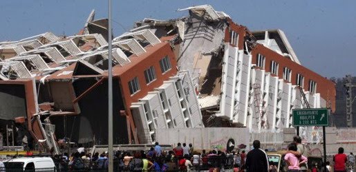
Earthquake
An earthquake (also known as a quake, tremor or temblor) is the result of a sudden release of energy in the Earth's crust that creates seismic waves.
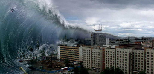
Tsunami
A tsunami also called a tsunami wave train, and at one time incorrectly referred to as a tidal wave, is a series of water waves caused by the displacement of a large volume of a body of water, usually an ocean, though it can occur in large lakes.
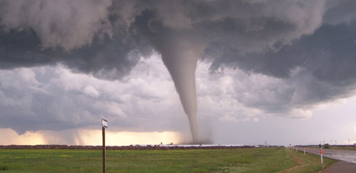
Tornado
A tornado (often referred to as a twister or, erroneously, a cyclone) is a violent, dangerous, rotating column of air that is in contact with both the surface of the earth and a cumulonimbus cloud or, in rare cases, the base of a cumulus cloud.
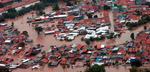
Floods
A flood is an overflow of an expanse of water that submerges land. The EU Floods directive defines a flood as a temporary covering by water of land not normally covered by water
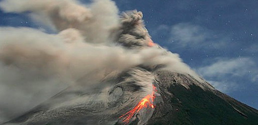
Volcanic Eruptions
Volcanoes can cause widespread destruction and consequent disaster through several ways. The effects include the volcanic eruption itself that may cause harm following the explosion of the volcano or the fall of rock.
Tropical Cyclone Movement and Track
8:29 AM
Steering winds
Although tropical cyclones are large systems generating enormous energy, their movements over the Earth's surface are controlled by large-scale winds—the streams in the Earth's atmosphere. The path of motion is referred to as a tropical cyclone's track and has been compared by Dr. Neil Frank, former director of the National Hurricane Center, to "leaves carried along by a stream".
Tropical systems, while generally located equatorward of the 20th parallel, are steered primarily westward by the east-to-west winds on the equatorward side of the subtropical ridge—a persistent high pressure area over the world's oceans. In the tropical North Atlantic and Northeast Pacific oceans, trade winds—another name for the westward-moving wind currents—steer tropical waves westward from the African coast and towards the Caribbean Sea, North America, and ultimately into the central Pacific ocean before the waves dampen out. These waves are the precursors to many tropical cyclones within this region. In the Indian Ocean and Western Pacific (both north and south of the equator), tropical cyclogenesis is strongly influenced by the seasonal movement of the Intertropical Convergence Zone and the monsoon trough, rather than by easterly waves. Tropical cyclones can also be steered by other systems, such as other low pressure systems, high pressure systems, warm fronts, and cold fronts.
Coriolis effect
The Earth's rotation imparts an acceleration known as the Coriolis effect, Coriolis acceleration, or colloquially, Coriolis force. This acceleration causes cyclonic systems to turn towards the poles in the absence of strong steering currents. The poleward portion of a tropical cyclone contains easterly winds, and the Coriolis effect pulls them slightly more poleward. The westerly winds on the equatorward portion of the cyclone pull slightly towards the equator, but, because the Coriolis effect weakens toward the equator, the net drag on the cyclone is poleward. Thus, tropical cyclones in the Northern Hemisphere usually turn north (before being blown east), and tropical cyclones in the Southern Hemisphere usually turn south (before being blown east) when no other effects counteract the Coriolis effect.
The Coriolis effect also initiates cyclonic rotation, but it is not the driving force that brings this rotation to high speeds – that force is the heat of condensation.
Interaction with the mid-latitude westerlies
When a tropical cyclone crosses the subtropical ridge axis, its general track around the high-pressure area is deflected significantly by winds moving towards the general low-pressure area to its north. When the cyclone track becomes strongly poleward with an easterly component, the cyclone has begun recurvature. A typhoon moving through the Pacific Ocean towards Asia, for example, will recurve offshore of Japan to the north, and then to the northeast, if the typhoon encounters southwesterly winds (blowing northeastward) around a low-pressure system passing over China or Siberia. Many tropical cyclones are eventually forced toward the northeast by extratropical cyclones in this manner, which move from west to east to the north of the subtropical ridge. An example of a tropical cyclone in recurvature was Typhoon Ioke in 2006, which took a similar trajectory.Landfall
Officially, landfall is when a storm's center (the center of its circulation, not its edge) crosses the coastline. Storm conditions may be experienced on the coast and inland hours before landfall; in fact, a tropical cyclone can launch its strongest winds over land, yet not make landfall; if this occurs, then it is said that the storm made a direct hit on the coast. As a result of the narrowness of this definition, the landfall area experiences half of a land-bound storm by the time the actual landfall occurs. For emergency preparedness, actions should be timed from when a certain wind speed or intensity of rainfall will reach land, not from when landfall will occur.
Multiple storm interaction
When two cyclones approach one another, their centers will begin orbiting cyclonically about a point between the two systems. The two vortices will be attracted to each other, and eventually spiral into the center point and merge. When the two vortices are of unequal size, the larger vortex will tend to dominate the interaction, and the smaller vortex will orbit around it. This phenomenon is called the Fujiwhara effect, after Sakuhei Fujiwhara.