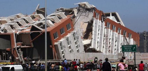
Earthquake
An earthquake (also known as a quake, tremor or temblor) is the result of a sudden release of energy in the Earth's crust that creates seismic waves.
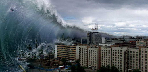
Tsunami
A tsunami also called a tsunami wave train, and at one time incorrectly referred to as a tidal wave, is a series of water waves caused by the displacement of a large volume of a body of water, usually an ocean, though it can occur in large lakes.
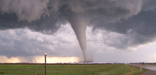
Tornado
A tornado (often referred to as a twister or, erroneously, a cyclone) is a violent, dangerous, rotating column of air that is in contact with both the surface of the earth and a cumulonimbus cloud or, in rare cases, the base of a cumulus cloud.
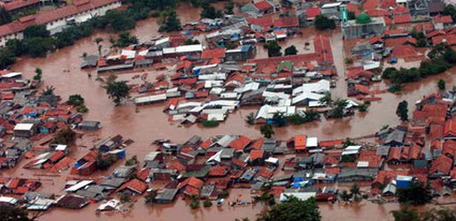
Floods
A flood is an overflow of an expanse of water that submerges land. The EU Floods directive defines a flood as a temporary covering by water of land not normally covered by water
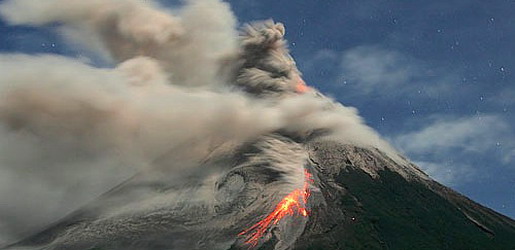
Volcanic Eruptions
Volcanoes can cause widespread destruction and consequent disaster through several ways. The effects include the volcanic eruption itself that may cause harm following the explosion of the volcano or the fall of rock.
How Heat Wave Occur
12:48 AM
In the summer in warm climates, an area of high pressure with little or no rain or clouds, the air and ground easily heats to excess. A static high pressure area can impose a very persistent heat wave.
The position of the jet stream allows air on one side to be considerably warmer than the other side. Heat waves are far more common and more severe on the warm side and at times an unusual position of the jet stream places unusual warmth in an unusual place for hot weather, and imposes a heat wave. El Niño and La Niña (opposite reaction to El Niño) can severely disrupt the positions of the jet streams.
Large desert zones and dry areas are more likely to get extreme heat because there is rarely any high cloud cover with very low humidity.
Winds from hot deserts typically push hot, dry air towards areas normally cooler than during a heat wave. During the summer an area that has no geographic features that might cool winds that originate in the hot deserts get little mitigation, especially near the summer solstice when long days and a high sun would create warm conditions even without the transport of hot air from other locations. Should such a hot air mass travel above a large body of water, as a sirocco of Saharan origin crossing the Mediterranean sea, it likely picks up much water vapor with a reduction in temperature but far greater humidity that makes the original desert air little less moderate as demonstrated in a high heat index. Heat waves can also come from air originating over tropical seas penetrating far into the middle latitudes heating further overland, as often occurs in the eastern United States and southeastern Canada. The heat island created by dense urbanization of large cities only exacerbate heat waves because of the weakness of night-time cooling.