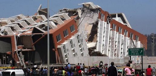
Earthquake
An earthquake (also known as a quake, tremor or temblor) is the result of a sudden release of energy in the Earth's crust that creates seismic waves.
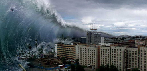
Tsunami
A tsunami also called a tsunami wave train, and at one time incorrectly referred to as a tidal wave, is a series of water waves caused by the displacement of a large volume of a body of water, usually an ocean, though it can occur in large lakes.
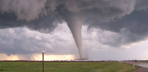
Tornado
A tornado (often referred to as a twister or, erroneously, a cyclone) is a violent, dangerous, rotating column of air that is in contact with both the surface of the earth and a cumulonimbus cloud or, in rare cases, the base of a cumulus cloud.
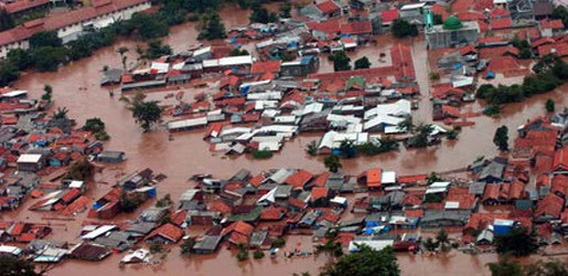
Floods
A flood is an overflow of an expanse of water that submerges land. The EU Floods directive defines a flood as a temporary covering by water of land not normally covered by water
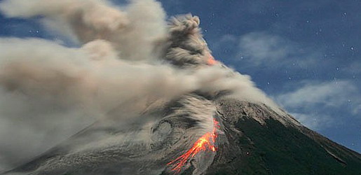
Volcanic Eruptions
Volcanoes can cause widespread destruction and consequent disaster through several ways. The effects include the volcanic eruption itself that may cause harm following the explosion of the volcano or the fall of rock.
Sendai Earthquake and Tsunami 2011
7:05 AM
The Sendai earthquake and tsunami was an 8.9 to 9.1-MW megathrust earthquake off the coast of Japan that occurred at 05:46 UTC (14:46 local time) on 11 March 2011. The epicenter was reported to be 130 kilometers (81 mi) off the east coast of the Oshika Peninsula, Tōhoku, with the hypocenter at a depth of 24.4 kilometers (15.2 mi). It was locally measured at the maximum possible 7 on the Japan Meteorological Agency seismic intensity scale in the northern Miyagi Prefecture, Japan,[10] 6 in other prefectures and 5 in Tokyo.
The earthquake triggered tsunami warnings and evacuations from Japan's Pacific coast and at least 20 countries, including the entire Pacific coast of North America and South America. The earthquake created tsunami waves of up to 10 meters (33 ft) that struck Japan and many other countries.] In Japan, the waves are reported to have travelled up to 10 kilometres (6 mi) inland.
News reports indicate that more than 605 people have died and 784 are missing in six different prefectures. The earthquake caused extensive damage in Japan, including heavy damage to roads and railways as well as fires in many areas, and a dam collapse. Around 4.4 million households in northeastern Japan were left without electricity and 1.4 million without water. Many electrical generators were taken down, and at least two nuclear reactors were damaged, which prompted evacuations of the affected areas, and a state of emergency was established. The Fukushima I Nuclear Power Plant experienced an explosion almost 24 hours after the initial earthquake; however, the blast was in an area not containing radioactive materials. Residents within a 20-kilometer (12 mi) radius of the Fukushima I Nuclear Power Plant and a 10-kilometer (6.2 mi) radius of the Fukushima II Nuclear Power Plant were evacuated.
The estimates of the Sendai earthquake's magnitude would make it the largest earthquake to hit Japan and one of the five largest earthquakes in the world since modern record-keeping began. It is thought to have been the largest earthquake within the boundaries of the North American and Pacific tectonic plates in 1,200 years.   | |
| Map showing the impact of the earthquake | |
| Date | 14:46:23, 11 March 2011 (+09:00) |
|---|---|
| Duration | 5 minutes |
| Magnitude | 8.9–9.1 MW |
| Depth | 24.4 km (15.2 mi) |
| Epicenter location | 38°19′19″N 142°22′08″E / 38.322°N 142.369°ECoordinates: 38°19′19″N 142°22′08″E / 38.322°N 142.369°E |
| Type | Megathrust earthquake |
| Countries or regions affected | Japan (primary) Pacific Rim (tsunami) |
| Total damage | Flooding and reports of major damage |
| Peak ground acceleration | 0.35g |
| Tsunami | Yes |
| Landslides | Yes |
| Aftershocks | at least 215 (25 above 6.0 MW) |
| Casualties | more than 605 dead, 784 missing |
